Geology 319 Structural Geology: The Architecture of Earth’s Continental Crust
Study Guide :: Unit 7
Case Study of the North American Cordillera
Overview
Unit 7 applies what you have learned about structures in this course to the North American Cordilleran Orogeny. Lesson 1 is a recap of the tectonic history of North America covered in Unit 1; it places the Cordilleran Orogen in the context of tectonism in the Phanerozoic. Lesson 2 describes the rocks of the Cordilleran Orogeny, including the largest batholith in the world, the Coast Range Batholith. Lesson 3 provides an overview of the Antler Orogeny, a precursor to the Cordilleran Orogeny. Lesson 4 discusses the Cordilleran Orogeny in detail, including the main geological features visible today, such as thrust faults and mountain ranges. Lesson 5 describes the period of extension after the Cordilleran Orogeny that produced the Basin and Range Province. Finally, Lesson 6 summarizes the ways in which topography has been generated by processes during and after the Cordilleran Orogeny.
Objectives
After studying this unit, you should be able to
- explain the historical development of tectonicism on the western margin of North America.
- label a map of North America to indicate where eugeosynclinal, miogeosynclinal, and platform rocks occur.
- explain what is meant by in situ and accreted terranes.
- explain how rocks of the Columbian Orogen differ from those of the Laramide Orogen.
- describe the three structural regions of the Laramide Orogen and the general characteristics of Laramide thrust faults.
- describe extensional tectonics and normal faulting in the Basin and Range Province.
- explain the nature of metamorphic core complexes and how they form.
- describe the ways in which topography has developed in the Cordillera.
Lesson 1: Overview of Phanerozoic Orogeny in North America
In Unit 1, we followed the story of the early North American continent through a long history of accretion, culminating in the supercontinent Rodinia. Rodinia then split apart, sending continental fragments to drift about the Earth once again. Despite the split, early North America had grown. What had once been a patchwork of small continents (the present Canadian Shield), ancient even then, now included orogens built from juvenile volcanic island arcs and volcanic continental arcs. The new addition formed a substantial part of what is now the United States. Figure 7.1, below, drawn along the Canada/US border, shows how North America collected a series of successive volcanic island arc chains and steadily accumulated eugeosynclinal, miogeosynclinal, and platform sedimentary deposits. The various geosynclinal sediments were derived by erosion of both the volcanic arcs and the Canadian Shield. There is some question among geologists about whether there was subduction in this region during the late Proterozoic to early Paleozoic, or whether the margin was passive during this time.
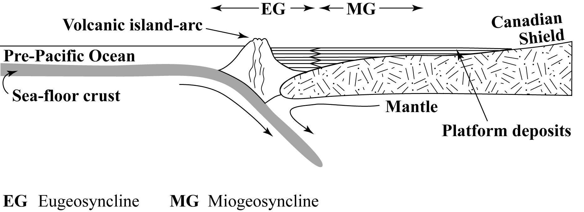
Figure 7.1. Accretion of the southern part of the North American continent
During the Paleozoic Era, North America underwent further orogeny on three fronts (Fig. 7.2): the Innuitian Orogen formed in the region of today's Arctic Islands; the Appalachian Orogen formed along the eastern margin of the continent; and the Antler Orogen developed on the western margin of the continent. The most dramatic evidence of orogeny visible today developed during the Mesozoic and Cenozoic Eras. It is the Cordilleran Orogen, which is also the largest of the world's orogens, running the length of North and South America.
Within the Cordilleran, Appalachian, and Innuitian orogens, the rocks can be divided into three categories (Fig. 7.2): eugeosynclinal deposits (EG; geosynclinal rocks deposited on oceanic crust), miogeosynclinal deposits (MG; geosynclinal rocks deposited on continental crust), and platform deposits (PF). In every case, the rocks grade from platform deposits beside and on top of the Canadian Shield, to miogeosynclinal rocks, and then to the deeper-water eugeosynclinal rocks that flank the North American continent. Platform rocks within the orogens have been folded and faulted along with the miogeosynclinal and eugeosynclinal rocks, while platform rocks outside the orogens remain in their original flat-lying orientation. One major exception is the Colorado Plateau within the Cordillera, where platform rocks have been uplifted to high elevation, without folding and with little faulting. Why the Colorado Plateau lacks the deformation that is present elsewhere in the Cordillera remains a mystery.
In this unit we will take a closer look at the process of orogeny by focusing on the tectonic activity on the western margin of North America, especially the Cordilleran Orogen.
Study Questions
- Name three Paleozoic orogenies that took place in North America.
- What is unusual about the Colorado Plateau?
Lesson 2: Geosynclinal Rocks of the North American Cordillera
Rocks of many different types and ages make up the Cordillera. Lesson 2 discusses these rocks.
2.1. Volcanic Rocks
Figure 7.3 shows the distribution of Cenozoic late- to post-orogenic volcanic rocks. Active volcanoes appear as black dots, and lava fields from extinct volcanoes are marked with grey shading. The locations of most of the vents from the extinct volcanoes are unknown, because they have been eroded or have been buried by lava. Although lava fields from extinct volcanoes are dotted throughout the North American Cordillera, there are two major volcanic fields: the Sierra Madre Occidental Mountains of Mexico, and the combined lava fields of the Columbia Plateau and the Snake River Plains.
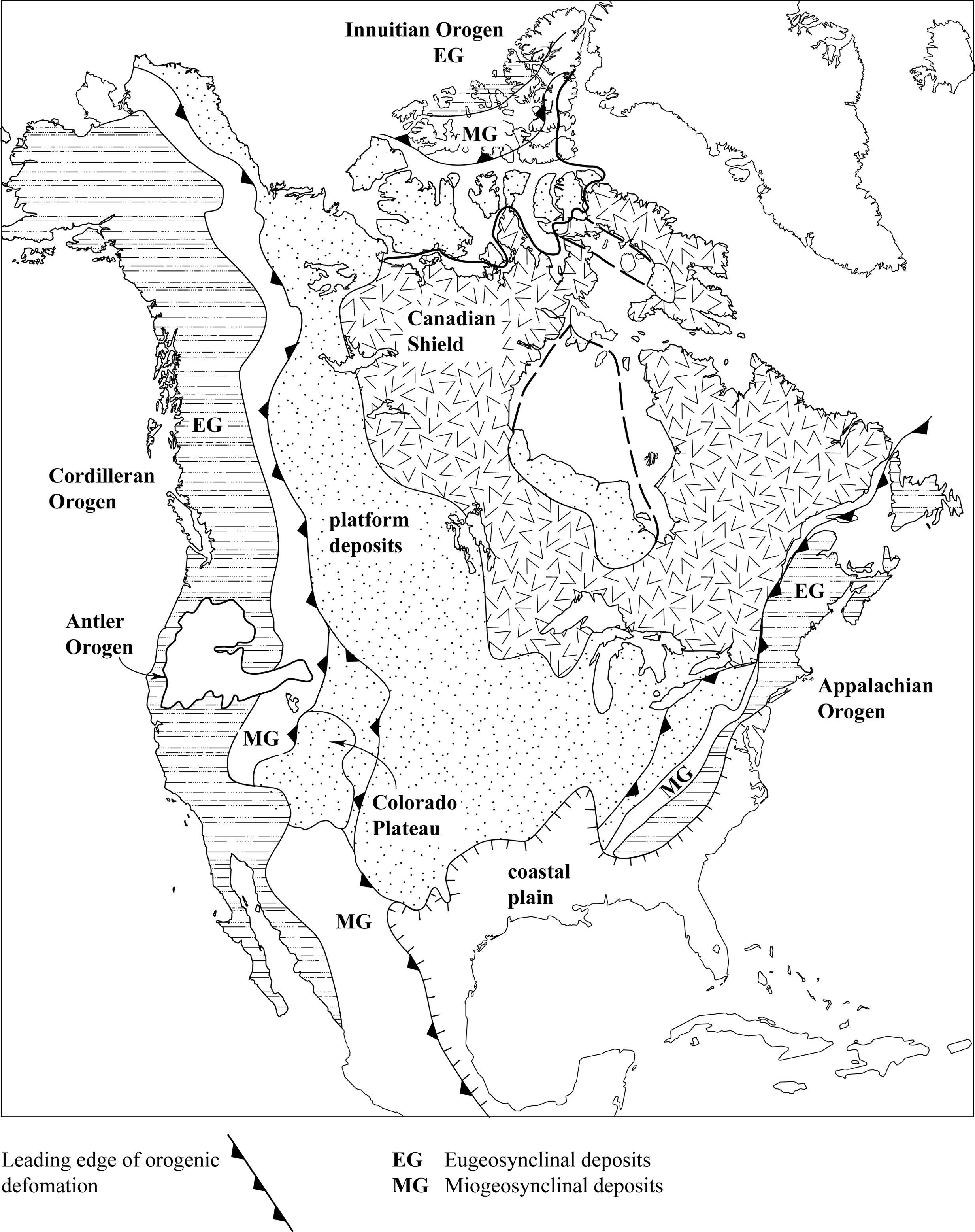
Figure 7.2. Phanerozoic orogens of North America
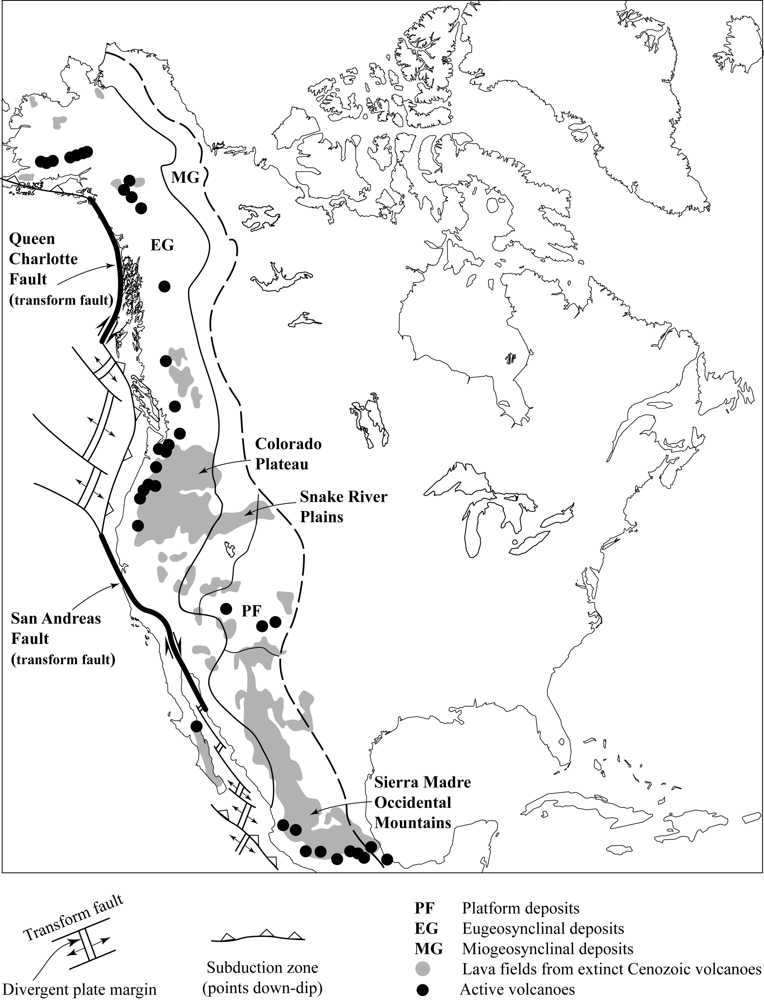
Figure 7.3. Cenozoic volcanic rocks of the North American Cordillera
Active volcanoes are related to modern plate tectonic movements. In Figure 7.3, divergent plate boundaries are shown by double thin lines; transform faults are indicated by the thin single lines that offset the spreading centres, and by heavier lines for the San Andreas Fault and the submarine Queen Charlotte Fault; subduction zones are shown by lines with open triangles, which point in the down-dip direction. Note that almost all the modern volcanoes occur on the overriding continental plate adjacent to the subduction zones.
The Cenozoic volcanic rocks are mainly basaltic lava flows (with some basaltic pyroclastic material) but some of the active or recently extinct volcanoes have produced rhyolite. All the volcanism has occurred on land. In most places, the volcanic rocks lie unconformably on older, deformed eugeosynclinal or miogeosynclinal rocks. The exception, once again, is the Colorado Plateau, on which Cenozoic volcanic rocks lie on undeformed platform rocks.
2.2. Platform Rocks
The platform rocks in and adjacent to the Cordillera range in age from early Paleozoic to Quaternary, and lie with angular unconformity on rarely exposed rocks of the Precambrian Shield. The rocks demonstrate a transition from marine conditions to terrestrial conditions as they get younger:
- Paleozoic rocks are mainly shallow marine limestone and shale, including numerous organic reef deposits. Other rocks occur locally, such as the Devonian salt deposits in the subsurface of Saskatchewan, which formed when the sea that covered the region dried up.
- Mesozoic rocks are mainly shale and sandstone. Some of the sandstones are shallow marine, but others are river and sand-dune deposits. Coal beds, the deposits formed in swampy forests, occur locally.
- Early Tertiary deposits are mostly river and lake sands, silts, and clay beds, with some coal, although the Coastal Plain of the Gulf of Mexico consists of uplifted sands and clays of shallow marine origin.
- Changes in the late Tertiary to Quaternary time have been mostly erosional (i.e., sediments were removed, not deposited), although glacial deposits coat much of northern North America, and river and lake deposits occur locally.
2.3. Miogeosynclinal Rocks
Miogeosynclinal rocks range in age from late Precambrian to early Tertiary, and they rest on the Canadian Shield just like the platform rocks. These rocks reflect a longer period of marine deposition than do the platform rocks, and they also provide clues to when deformation ceased.
- Precambrian rocks include sand and shale deposited in deltas; and sand, shale, and limestone deposited in a shallow marine environment. Some volcanic rocks are also present.
- Paleozoic rocks are mainly shallow marine limestones and shales, similar to platform rocks of the same age.
- Mesozoic rocks are also similar to their platform age-equivalents, except for a nearly complete lack of terrestrial deposits.
- Cenozoic deposits are mostly terrestrial (lake, river, and glacial). The earliest Cenozoic rocks are deformed along with the older rocks, but the youngest are flat-lying, and occur in structurally controlled or erosional valleys.
2.4. Eugeosynclinal Rocks
Eugeosynclinal rocks originated in two very different ways: in situ terranes and accreted terranes.
In situ terranes consist of rocks that were deposited within a few hundred kilometres of the miogeosyncline. These are also called juvenile deposits, and the region of deposition is called a juvenile terrane. In situ eugeosynclinal terranes contain rocks that are either sedimentary deposits that are deeper-water age-equivalents of miogeosynclinal strata; or they are volcanic-arc to subduction-zone to back-arc volcanic or sedimentary rocks that were probably deposited within the eugeosyncline. These in situ rocks range in age from late Precambrian to early Mesozoic, and every geological time period is represented by a wide range of both volcanic and sedimentary rock types.
Accreted terranes (or exotic terranes) consist of rocks that were deposited in distant and unknown locations. Plate tectonic movements then transported these terranes as large blocks (perhaps as islands) to the western margin of North America before and during the Cordilleran Orogeny. Terrane boundaries are marked by major thrust faults or strike-slip faults.
Strictly speaking, accreted terranes are not part of the eugeosyncline, because the rocks they contain were not deposited within the Cordilleran geosyncline. Nonetheless, they now form integral parts of the Cordilleran Orogen. As a result, the eugeosynclinal area contains a complex jumble of rock types of origins that are only modestly understood. Accreted terranes are geological “misfits” in one or more of the following ways:
- They bear no lithological relationship to rocks in adjacent in situ terranes.
- They are of markedly different age than rocks in adjacent terranes of either in situ or accreted origin.
- They have been folded and faulted very differently from rocks in adjacent terranes of either origin.
- They have markedly different metamorphic grades from rocks in adjacent terranes.
Study Questions
- Where do most volcanoes exist in North America today?
- Describe the two kinds of terranes found in eugeosynclinal rocks.
- How can exotic terranes be distinguished from in situ terranes?
Lesson 3: Antler Orogeny
The Antler Orogeny was a middle to late Paleozoic precursor of the main period of folding and faulting that formed the Cordillera. The Antler Orogeny caused weak to moderate deformation in the western United States (Fig. 7.4). Parts of the Antler Orogen are now buried by younger deposits, so it is difficult to know its true geographic extent, but from the outcrops that have been identified, the Antler Orogen appears to be about 1/10 the size of the Cordilleran Orogen.
Figure 7.5a is drawn through the Antler Orogen. It represents the time period from ~450 Ma, when thrust faulting and uplift began, to ~200 Ma, by which time the Antler Mountains were nearly eroded to sea level and much of the Antler Orogen was buried by late Paleozoic to early Mesozoic sediment. Geosynclinal sediment (stipple pattern) was derived partly from the erosion of the Antler Mountains and partly from erosion of the volcanic arc and Canadian Shield.
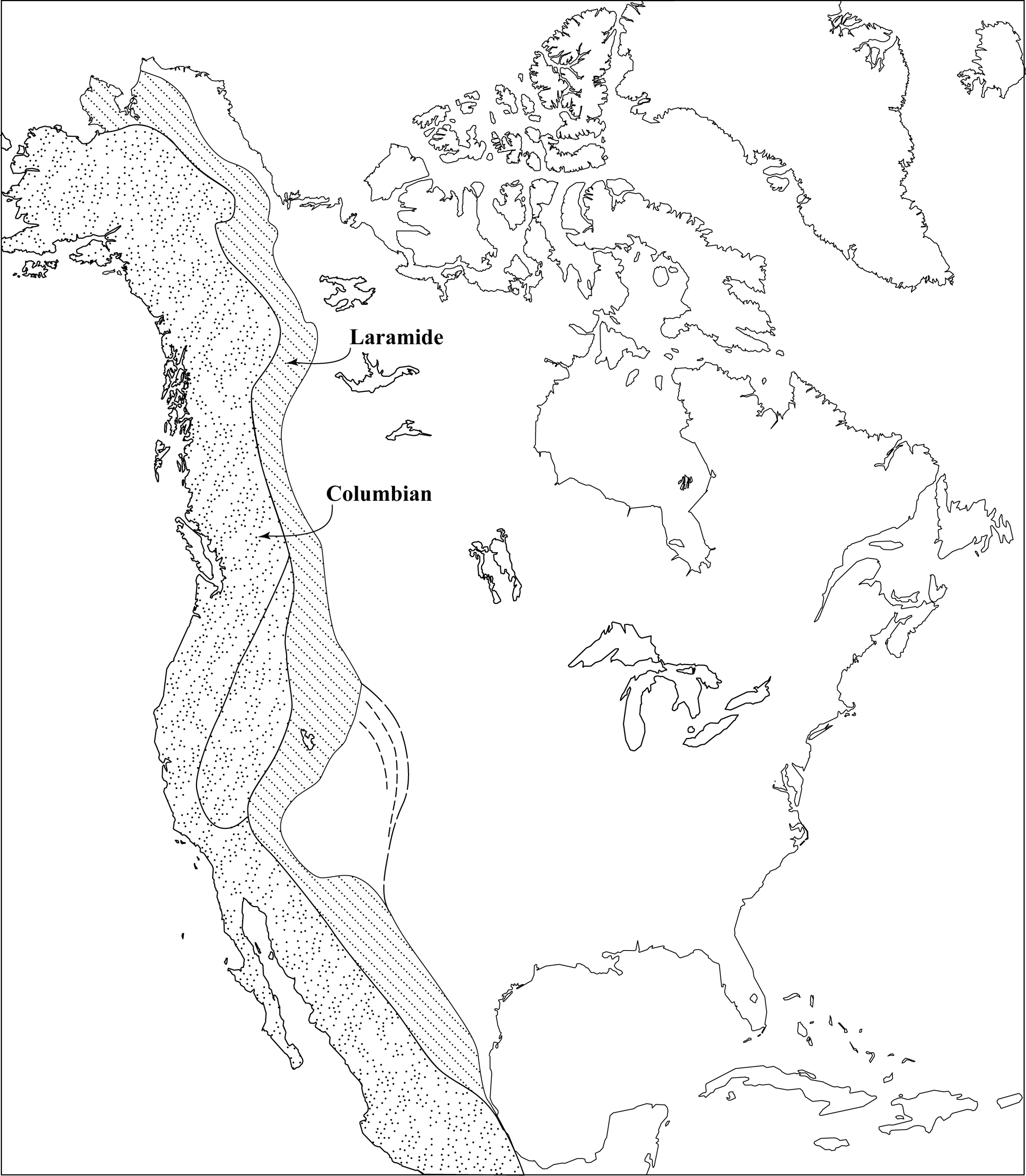
Figure 7.4. Orogens of western North America
The Antler Orogeny had two main features:
- It produced west-dipping thrust faults. The thrust faults moved early to middle Paleozoic eugeosynclinal rocks eastward by as much as 100 km. These rocks now lie on miogeosynclinal and platform rocks of the same age or younger.
- It caused uplift of a mountainous terrane. The mountains are the source of sediments that were deposited throughout the adjacent parts of the Cordilleran geosyncline during middle Paleozoic to early Mesozoic time.
Study Questions
- When did the Antler Orogeny occur?
- What were the main features of the Antler Orogeny?
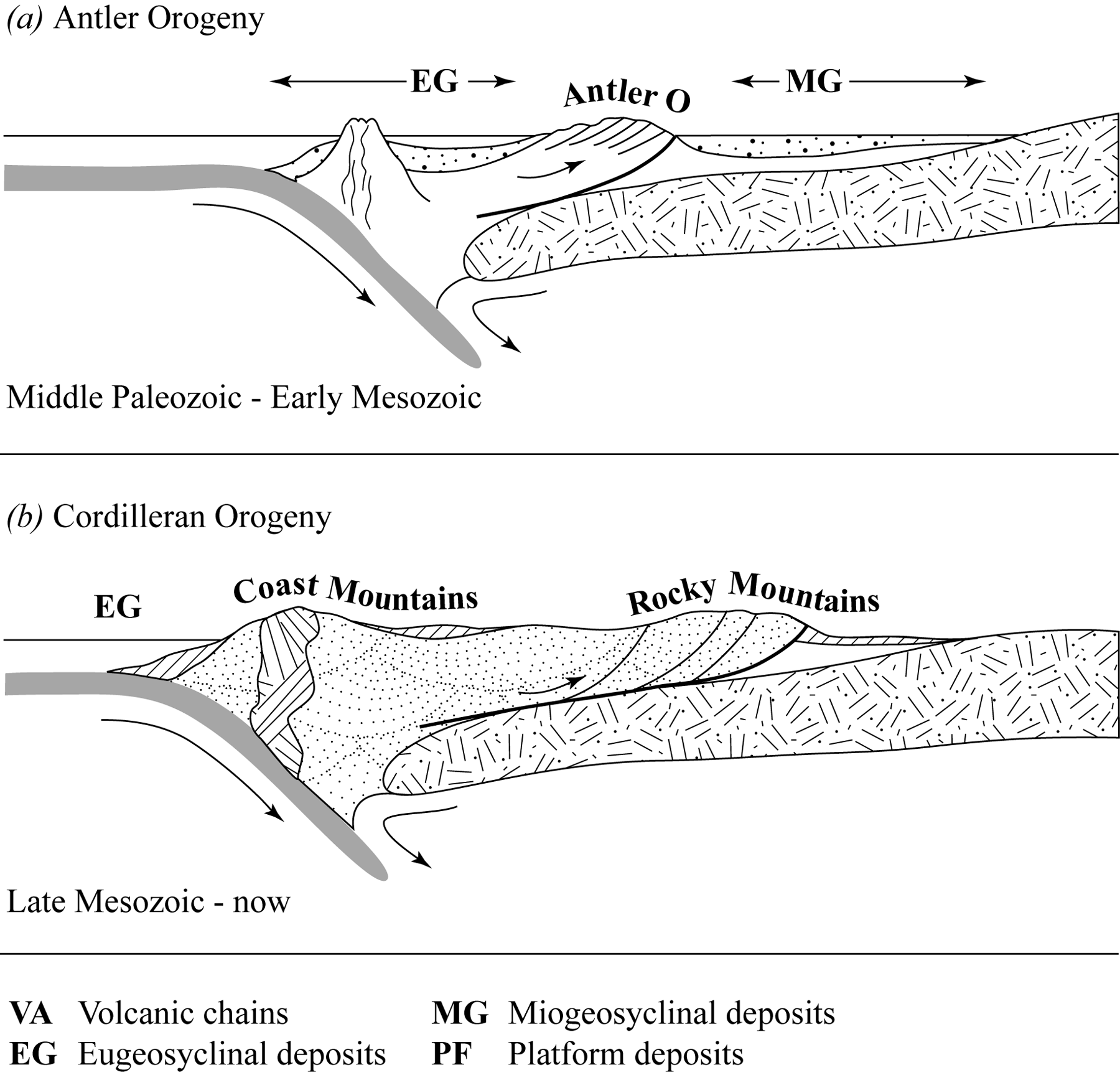
Figure 7.5. Orogeny on the western margin of North America
Lesson 4: The Cordilleran Orogeny
The Cordilleran Orogeny began in the late Triassic and ended in early Tertiary. Its strongest effects occurred between the middle Jurassic and the end Cretaceous, so it is commonly referred to as a late Mesozoic orogeny. The Cordilleran Orogeny had a complex development, producing different features in different regions. For our purposes, we will consider two phases:
- The Columbian Orogeny took place from late Triassic to late Cretaceous time, and affected mainly the eugeosynclinal part of the Cordilleran geosyncline (Fig. 7.4).
- The Laramide Orogeny (late Cretaceous to early Tertiary) affected mainly the miogeosynclinal and platform parts of the Cordilleran geosyncline (Fig. 7.4).
Despite the separate names for the different times and locations of orogeny, be aware that orogenesis was a continuous process, and the names are mainly for convenience of discussion.
Figure 7.5b shows the situation north of the Canadian/American border from the time of intrusion of the Coast Range Batholith (forming the Coast Mountains) through the Laramide thrust faulting of the Rocky Mountains, to the present. Late Mesozoic to early Tertiary syntectonic deposition (indicated by vertical stipple) has taken place off the west coast of the Coast Mountains in structurally-controlled basins within the Cordillera and on the eastern side of the Cordillera. The region affected by the Antler Orogeny is included within the Cordilleran Orogen, and is represented by the squiggle-fold lines.
The Cordilleran Orogeny produced three main effects: igneous intrusions with local contact metamorphism; thrust faulting and folding along with widespread regional metamorphism; and uplift, generating the Cordilleran mountain belts.
4.1. Igneous Intrusions
Dozens of syntectonic granitoid stocks and batholiths are present mainly in the eugeosynclinal region. Among these is the largest batholith in the world, the Coast Range Batholith, which forms most of the Coast Mountains running the full north-south length of the west coast of British Columbia. Two other large batholiths are the Idaho Batholith and the Sierra Nevada Batholith (Fig. 7.6). These intrusive bodies consist of many separate plutons that have been intruded adjacent to one another. The plutons vary in age from mid-Jurassic to early Tertiary, and also vary in composition. Most resist erosion more than the surrounding country rock, so they form hilly to mountainous regions.
Overall, the batholiths are highly elongate and trend parallel to the length of the orogen. The main folds and faults also trend parallel to the length of the orogen, suggesting that the stresses that controlled deformation also controlled the emplacement of magma.
4.2. Thrust Faulting and Folding
All rocks that were deposited on the western margin of North America before the Cordilleran Orogeny have been displaced by thrust faults and have been folded. Almost all faults and fold axial planes strike parallel to the length of the orogen. The exception is the Colorado Plateau, whose sediments have not been deformed and which has deflected the orientations of faults and folds around itself.
In the Columbian Orogen, the rocks now exposed at the surface were deeply buried during orogenesis, and experienced temperatures of several hundred degrees Celsius. These rocks have therefore undergone regional metamorphism. Ductile folding and faulting has occurred, causing variable amounts of ductile deformation of grains. Polyphase deformation resulted in early faults and folds having been refolded. Most of the ductile thrust zones in the eastern Columbian Orogen dip to the west, but elsewhere they dip either east or west.
The amount of crustal shortening that occurred during the Columbian phase of orogeny is difficult to determine, because shortening by folding and faulting has been offset by the emplacement of batholiths and the addition of exotic terranes. An estimate based on admittedly limited knowledge suggests that the Columbian Orogen is less than half as wide as the original, undeformed rocks.
The Laramide Orogen is known for its brittle thrust faults, most of which dip west, and some of which are folded. For the most part, deformation took place in a single phase. There is very little metamorphism other than that in the western parts of the orogen that are older, and which were more deeply buried. Almost all the shortening across the Laramide Orogen took place by brittle thrust-fault slippage. Several faults have undergone almost 100 km displacement, and the total shortening is about 200 km, or approximately 50 per cent for most sections of the Laramide system.
A series of mountain belts that are still present today formed as a result of Laramide thrust faulting (Fig. 7.6). From south to north, these are the Sierra Madre Oriental; the Southern Rocky Mountains; the Middle Rocky Mountains; the Sevier Mountains; the Northern Rocky Mountains, which extend from the junction of the Seviers and the Middle Rockies up to the British Columbia/Yukon border; the Mackenzie Mountains in the Yukon and Northwest Territories; and the Brooks Range in Alaska. As shown in Figure 7.6, most of the belts include a range of foothills along their eastern flanks. These would be shown separately on more detailed maps.
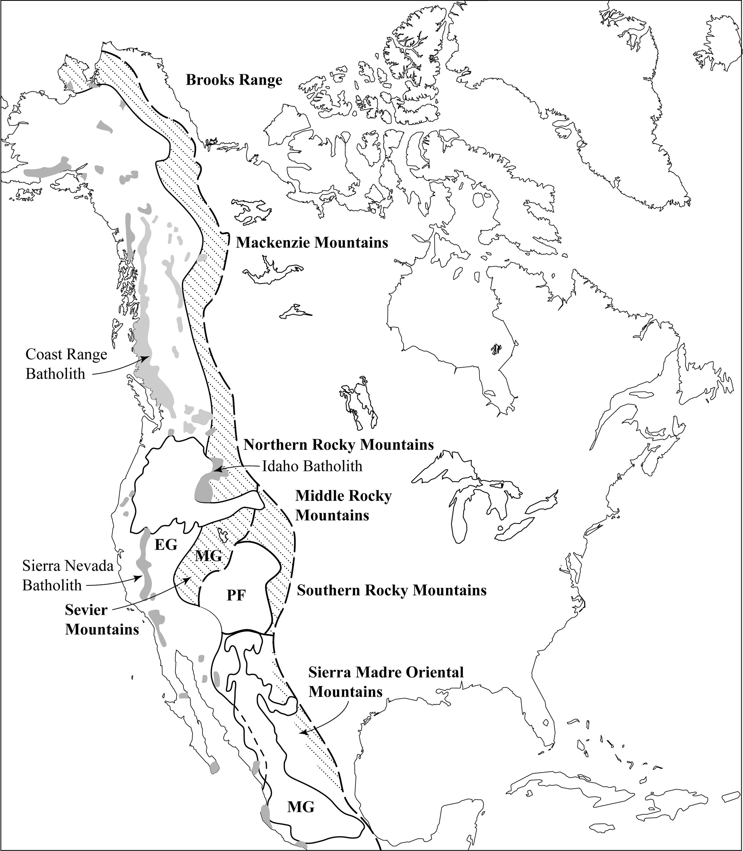
Figure 7.6. Intrusive rocks and mountain belts
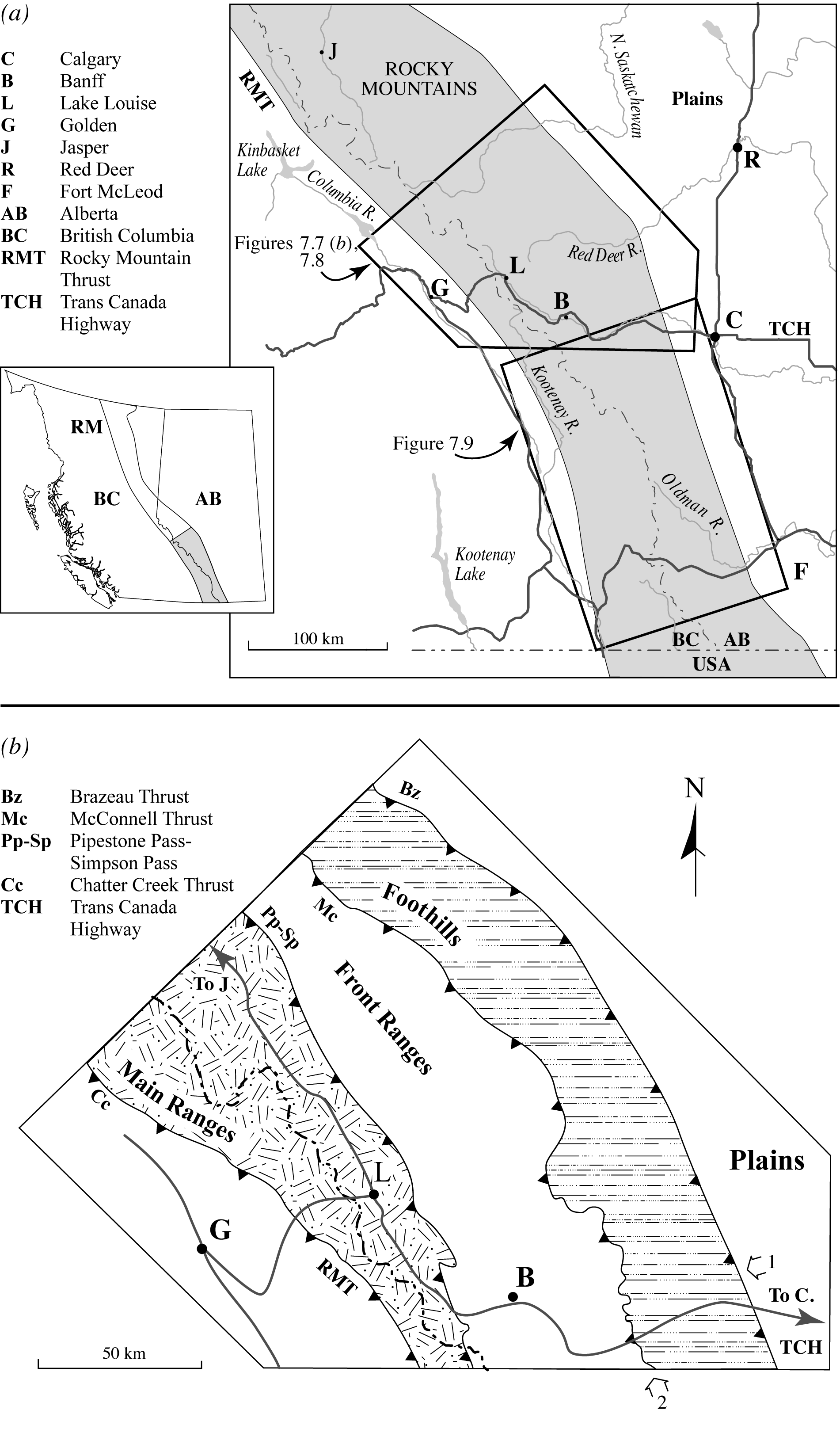
Figure 7.7. Topographic and structural subdivisions in the Laramide Orogen
In Figure 7.7, a segment of the Northern Rocky Mountains shows the structure of the Laramide Orogen in detail. Thrust faults divide the Rocky Mountains into three topographic/structural units:
- The Foothills are hills and small mountains carved primarily by the erosion of thrust-faulted Mesozoic rocks (grey in Fig. 7.8) with only local patches of upthrust Paleozoic rocks (untextured in Fig. 7.8). The hills are mainly sandstone (limestone in the Paleozoic patches), and the valleys are occupied mainly by low resistance shale. The thrust faults occur either within the valleys or along the eastern sides of some of the ridges.
- The Front Ranges are characterized by rocky peaks and ridges of Paleozoic limestone. Most of the major valleys are occupied by the more easily eroded Mesozoic sandstones and shales, and thrust faults occur on the eastern side of most of the major ridges. In the lower right-hand corner of Figure 7.7, double arrows labelled 1 and 2 indicate the directions of view for the photographs in Figures 4.11a and b (Study Guide, Unit 4), respectively, showing down-dip and along-strike views of the McConnell Thrust with the Front Ranges towering over the Foothills.
- The Main Ranges are even loftier peaks and ridges than the front ranges, some consisting of Paleozoic limestone and lower Cambrian quartzite, but others consisting of upthrust blocks of Precambrian metamorphosed sandstones and slates (stipple pattern in Fig. 7.8). Valleys are occupied mainly by Paleozoic shales and Precambrian slates. As in the Front Ranges, thrust faults commonly occur along the eastern sides of major ridges. In this region of high elevation, the Columbia Ice Field (between Lake Louise, L, and Jasper, J) occurs as a remnant of the last ice age.
Thrust faults in this region, as elsewhere in the Rockies, are not necessarily single planar surfaces. They form zones of fault gouge to fault breccia up to several metres thick, flanked by up to tens of metres of folded and fractured rock. Slickenside lineations are fairly common. The thrust faults also branch, intertwine, and overlap with one another, such that as one dies out it is replaced to the side or by a branching mate that increases in slippage as the other fault decays.
Replacement by branching can be seen by following the Simpson Pass Thrust northwestward from its southern end in Figure 7.8, where it has brought Precambrian rocks up from the west onto Paleozoic rocks in the east (a displacement of 75 km). The Simpson Pass Thrust throws a branching fault, the Pipestone Pass Thrust, and then decays in displacement as the Pipestone Pass Thrust grows. Together, both faults maintain the 75 km displacement. The Pipestone Pass Thrust eventually brings Precambrian rocks over Paleozoic rocks (look for the stipples along Pp in Fig. 7.8) and becomes the major structure. The Simpson Pass fault dies out completely farther to the northwest after the entire 75 km displacement has been transferred to the Pipestone Pass Thrust.
The region illustrated in Figure 7.8 has the following general characteristics of the Laramide Orogen:
- west-dipping thrust faults
- major faults tend to decrease in dip downwards and eventually tend to merge with the unconformity at the top of the subsurface extension of the Canadian Shield (a major decollement)
- branching, especially of minor, unnamed faults
- a rise in overall elevation from the Foothills to the Main Ranges
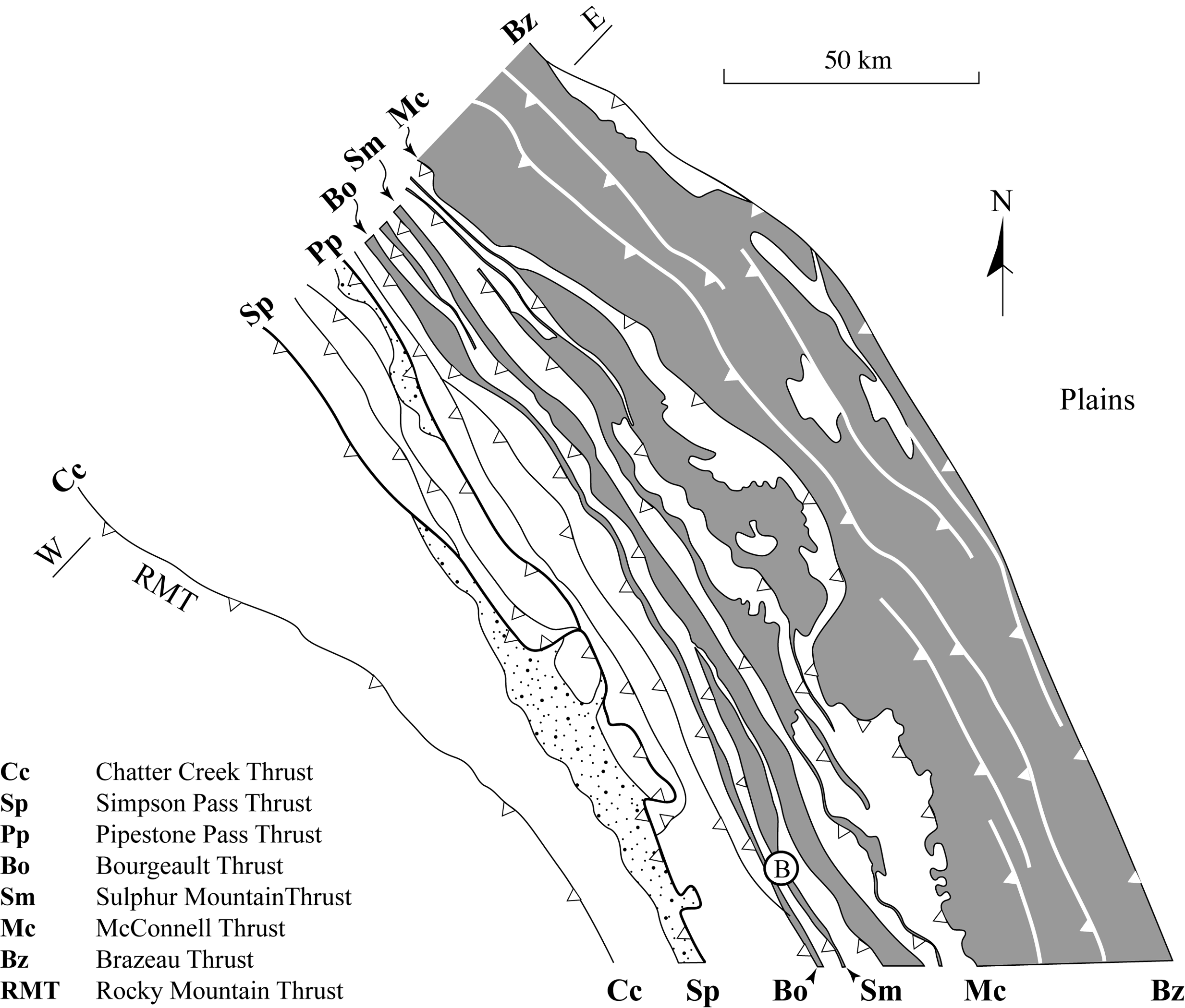
Figure 7.8. Detail of faults in the Northern Rockies
Figure 7.9a and b show palinspastic and deformed block diagrams drawn for the area just southeast of Figure 7.8. A palinspastic block diagram show the original locations of rocks that have since been faulted. The palinspastic diagram is constructed by “unslipping” the faults. Labels are the same as those used in Figures 7.7 and 7.8, with the addition of the Lewis Thrust Fault (Lw). The Simpson Pass and McConnell faults both die out and are replaced by the transfer of displacement to the Lewis Thrust (especially for the McConnell fault). Figure 7.8b uses the top of the Paleozoic rocks as a reference plane, showing the fault displacement. (This diagram does not show the topography that has developed by erosion.)
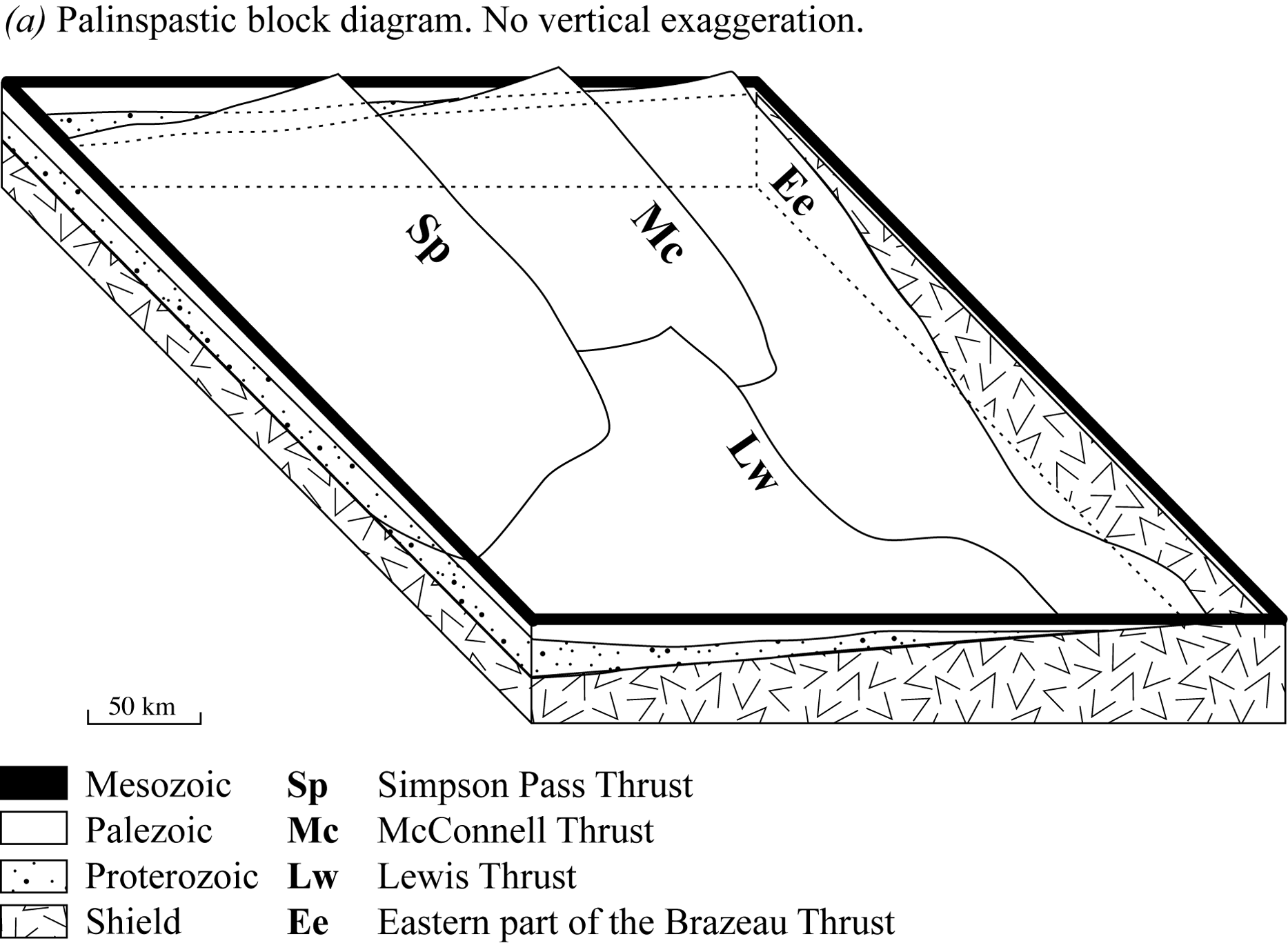
Figure 7.9. Block diagrams of Laramide faults
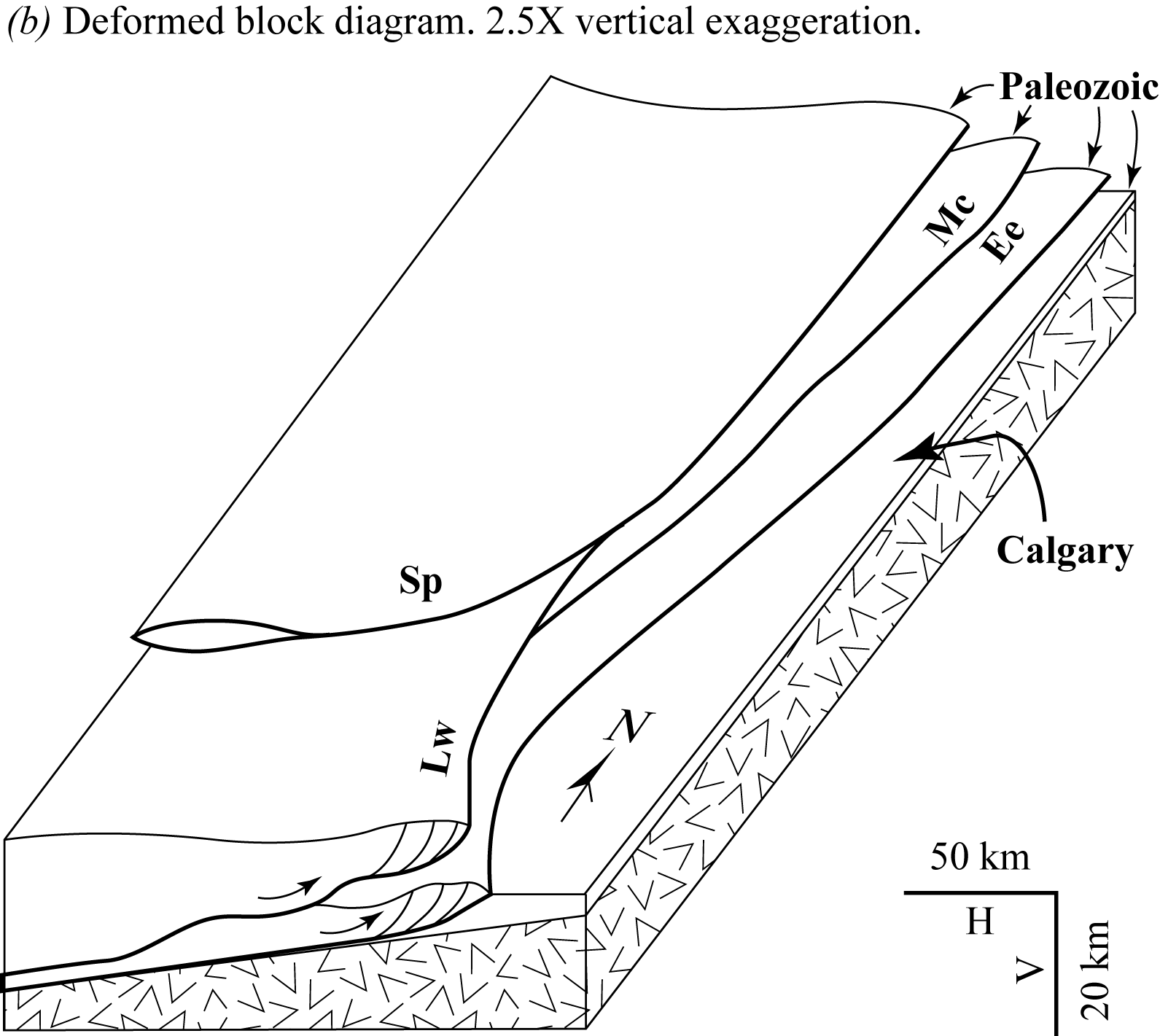
Figure 7.9. cont. Block diagrams of Laramide faults
Study Questions
- When did the Cordilleran Orogeny occur?
- The Cordilleran Orogeny is divided into two phases: the Columbian Orogeny and the Laramide Orogeny. Describe these two phases.
- The Cordilleran Orogeny produced one of the largest igneous intrusions. What is the name of this intrusion?
- Thrust faults divide rocks of the Laramide Orogen into three units. What are these units?
Lesson 5: Post-Laramide Extensional Tectonics
Although compressional Laramide tectonism ended in early Tertiary time (~55 Ma), the Cordillera did not become tectonically inactive. Instead, it entered a new phase of horizontal NE-SW extension in approximately the same direction in which shortening had previously taken place! The extensional tectonic phase was restricted primarily to the region known as the Basin and Range Province (Fig. 7.10, Study Guide). Some geologists think that the Basin and Range Province has undergone 100 per cent stretching, and is now double its original width. It is unclear why the tectonic regime changed from compressional to extensional. One suggestion is that the movements of nearby tectonic plates changed beginning about 50-55 Ma and continuing up to at least 5 Ma. Not many other orogens seem to have undergone this type of extensional tectonics, but it is important in the Andes of South America, and has also occurred in a number of oceanic rift zones such as the mid-oceanic rifts, the Red Sea, the North Sea between Great Britain and mainland Europe, and the Philippine Plate.
5.1. Normal Faulting in Extensional Tectonics
Figure 7.11a shows how normal faulting plays a part in the stretching process, especially in the upper, brittle part of the continental crust (B-brittle upper crust; D-ductile lower crust). The lower parts of these faults are ductile faults. Some workers think that ductile faulting extends through the entire crust, with decollement at the top of the mantle. However, most agree with the model shown in Figure 7.11a, where the lower crust undergoes a more homogeneous ductile stretching not restricted to fault zones. Due to this stretching, the crust is thinned, resulting in a decrease in vertical pressure and isostatic uplift; and at the Earth's surface, a series of graben, half-graben, and horsts are formed. Take a minute to identify and label these on Fig. 7.11a. Major graben are outlined by major listric normal sole-faults, whose expressions at the topographic surface are called breakaway faults.
Figure 7.11b shows three developmental stages in the evolution of a major extensional sole fault and the splay faults that branch off of it into the hanging wall block. (Ductile fault zones are indicated by the stipple pattern). In this evolution, a number of important processes take place:
- Movement along a curving fault causes the fault block to rotate, resulting in a reduction in the dip of the faults above. This is similar to the rotation of slump blocks, although on a much larger scale.
- Where rotation causes faults to change from steeply dipping to gently dipping, new steeply dipping faults may form later and offset the earlier-formed structures (Fig. 6.136, Davis, Reynolds, & Kluth. p. 333).
- Uplift occurs, arching the sole fault and further modifying the dips of the splay faults, so that parts of the system originally undergoing ductile faulting are brought into the zone of brittle faulting. This causes mylonites to become brecciated.
- Continued stretching and normal faulting may cause the originally ductile zone to become completely stripped of overlying rock, so that it is eventually exposed at the Earth's surface even without normal erosion. This is sometimes referred to as tectonic stripping. The cause of the uplift is unclear, but it is likely related, at least in part, to isostatic uplift related to tectonic thinning. It could also be caused by still-buried intrusions.
- Ordinary erosion may wear through the arched sole fault, exposing the footwall rocks below (the core of the structure). This is a variety of fenster, or fault window.
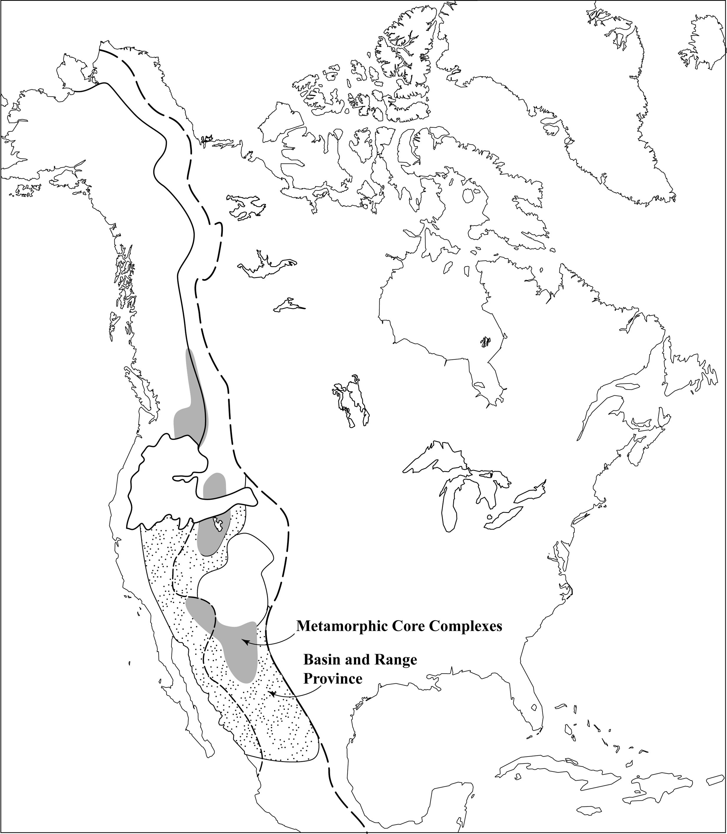
Figure 7.10. Extension in the Basin and Range Province
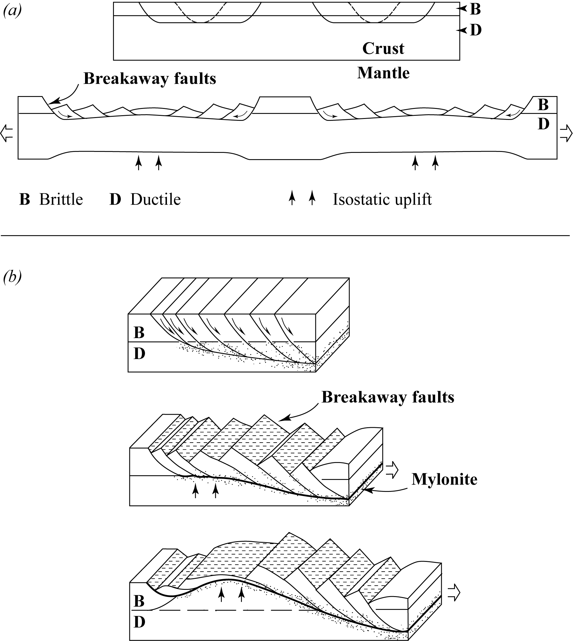
Figure 7.11. Normal fault development
5.2. Metamorphic Core Complexes
In many places in the Basin and Range Province, extensional sole faults have cut into the subsurface extension of the Canadian Shield so that it forms the footwall block, and Cordilleran geosynclinal rocks (plus young volcanic, locally) form the hanging wall material. In such cases, the arched Precambrian Shield rocks may be exposed at the topographic surface (in the fault window), forming a metamorphic core complex. Several dozen metamorphic core complexes are exposed in the Basin and Range Province (Fig. 7.10), and ten of these are in the State of Arizona (Fig. 7.12, solid black in the inset map).
Northeast of Tucson, three small (but picturesque) mountain ranges display the type of structure shown schematically in the central parts of the before-and-after sketches of Figure 7.11a. They are bounded by faults, as shown on both the main map and cross-section (Fig. 7.12; the cross-section runs northeast from Tucson—T). Faults are indicated on both the map and the cross-section as either a single heavy line (for brittle faults) or as heavy lines bounding a dot-textured band (indicating the ductile fault rock, including mylonite). Fault lines are solid where they crop out, and dashed where they are buried by the desert sands that occupy the valleys (non-textured areas on Fig. 7.12). The black squares are on the down-dip, hanging wall side of the fault lines.
The central mountain range of this group is the Galiuro Mountains (GM), which is the horst between two breakaway faults. Here, the rocks forming most of the mountains are Tertiary volcanics (“v” pattern) that lie over Precambrian rocks (“+” pattern), which crop out in several small patches (not shown on the map).
The southwestern range, the Santa Catalina Mountains (SM) and the Rincon Mountains (RM), exposes a metamorphic core complex (“+” pattern) of mainly Proterozoic gneisses, intruded by Cretaceous to Early Tertiary granite bodies. On the northeastern side of this mountain range, the metamorphic core complex is overlain by a carapace (hanging wall block; vertical line pattern) of mainly Paleozoic and Mesozoic sedimentary rocks that is in brittle fault contact with the metamorphic core complex. On the southwestern side the carapace is in brittle fault contact (heavy line with squares) with a ductile fault zone several kilometres wide (dot pattern), involving mainly rocks of the metamorphic core complex.
The brittle faulting has brecciated the older mylonites, but is thought to represent a post-arching continuation (reworking) of the same long-term fault displacement that began with ductile faulting. The entire fault structure, from the breakaway to the arched and reworked ductile fault zone, dips generally to the southwest and is called the Santa Catalina Detachment fault (SeD).
A similar situation exists in the northeastern range, the Jackson Mountains (JM) and Pinaleno Mountains (PM), but here the major sole fault (the Eagle Pass Detachment fault—EPD) dips generally to the northeast, and Tertiary volcanic rocks form the hanging wall on the southwestern flank of the mountains (these, however, overlie Mesozoic to Paleozoic hanging wall rocks). Ductile fault zone rocks in this region contain well-developed slip indicators such as C-S fabric. Brittle fault zones contain fault breccia and slickenside lineations. The carapace rocks have undergone both Laramide compressional tectonics and post-Laramide extension, so the structure of the rocks (locally) is rather complicated.
Study Questions
- Why is isostatic uplift an outcome of extensional tectonics?
- What kind of fault is a breakaway fault?
- What kind of structure is the core of a metamorphic core complex?
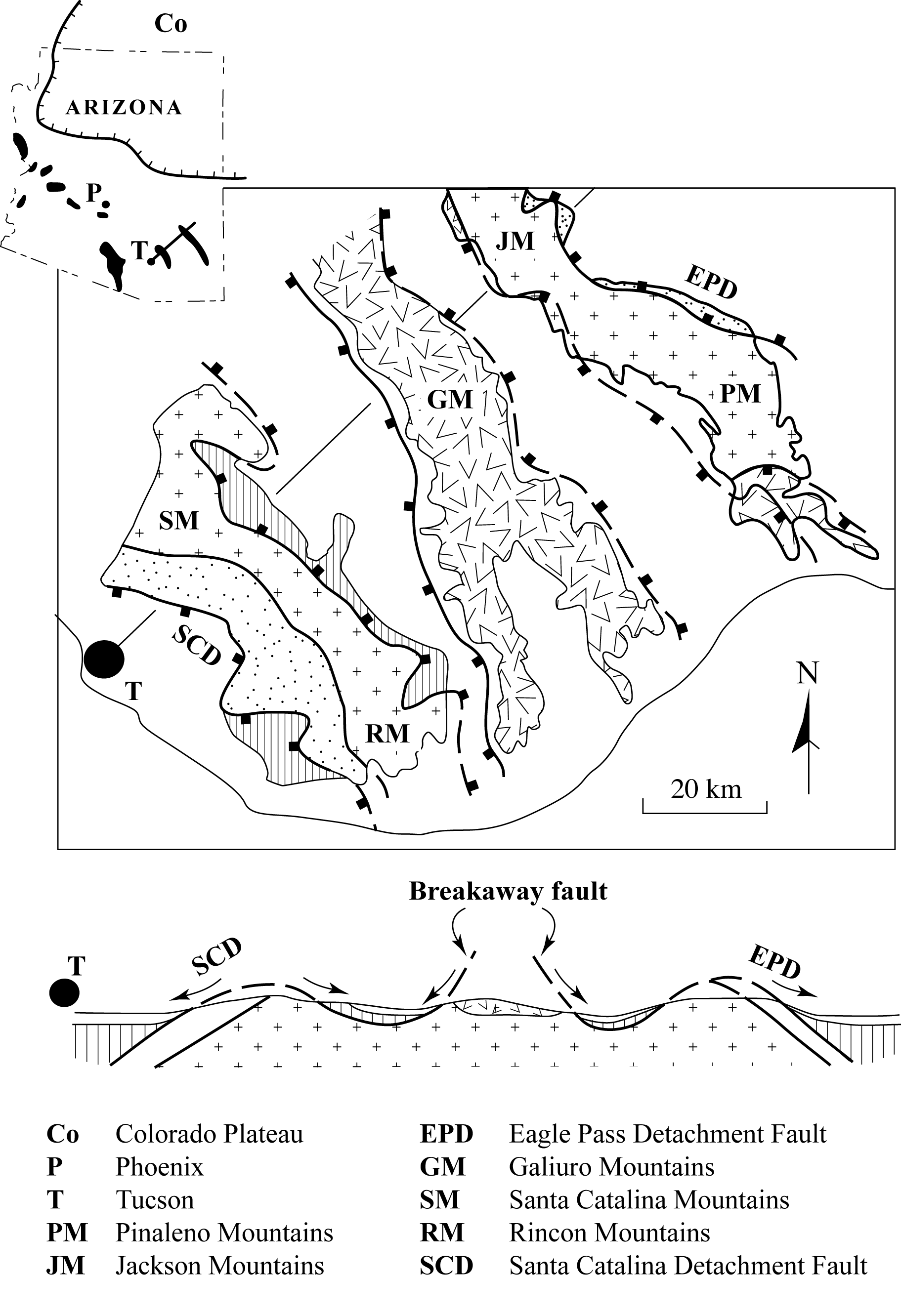
Figure 7.12. Metamorphic core complexes in Arizona
Lesson 6: Topography in the Cordillera
The topography of the North American Cordillera, like the topographical surfaces of every other rocky body on Earth, is a direct result of the processes that have occurred in the past. In the Cordillera, as in other young orogens, the high elevation is the result of uplift that was a byproduct of intrusion, folding, and thrust faulting. The uplifted rocks will eventually be worn down, exposing the roots of the orogen, like that of more ancient orogens.
A variety of controls affect the topography of the various mountain ranges that comprise the Cordillera:
- Some, such as the Coast Ranges of British Columbia, are caused by the erosional resistance of large batholiths.
- Others, such as the many separate ranges that make up the Laramide orogenic segment, are formed mainly by the thick, resistant, Paleozoic limestone or quartzite beds that occur in the hanging walls of the many thrust faults.
- In the Basin and Range Province, most of the mountain ranges are either on the footwall block of the extensional normal faults or in the arched metamorphic core complexes.
Study Question
- What are three ways in which topography is generated in the Cordillera?
Assignment 7
You should now complete the theory portion of Assignment 7, which you can find in the assignment drop box. You will submit this assignment to your tutor for grading after you have also completed the lab portion.
Answers to Study Questions
Lesson 1
- Innuitian, Appalachian, and Antler orogenies
- The Colorado Plateau is unusual because it was uplifted during the Cordilleran Orogeny, but did not undergo folding or faulting.
Lesson 2
- In North America today, most modern volcanoes are on the western edge of the continental plate, adjacent to the subduction zones.
- Eugeosynclinal rocks include in situ terranes, which were formed near the continental margin, and exotic terranes, which were not deposited in the Cordilleran geosyncline. The exotic terranes formed elsewhere and were “imported” and then accreted. Often, little is known about where the exotic terranes came from.
- Exotic terranes can be distinguished from in situ terranes because they are “misfits” in some way. Exotic terranes may have rocks that do not fit in with the geology of nearby terranes. They may have a very different geological age than nearby terranes. Exotic terranes may be deformed very differently or may have a very different metamorphic grade than adjacent terranes.
Lesson 3
- Thrust faulting and uplift in the Antler Orogen began 450 Ma ago. By 200 Ma ago, rocks of the Antler Orogen were nearly eroded to sea level.
- The Antler Orogeny produced westward-dipping thrust faults and mountains that were a source of sediment to the Cordilleran geosyncline.
Lesson 4
- The Cordilleran Orogeny was active from the late Triassic to the early Tertiary, but the strongest phase occurred from the middle Jurassic to the end Cretaceous.
The Columbian Orogeny took place from the late Triassic to the late Cretaceous. It affected the eugeosynclinal part of the Cordillera. Rocks from the Columbian Orogeny show regional metamorphism and ductile folding and faulting. This reflects the fact that the rocks that are now exposed were once deeply buried, where they were exposed to high temperatures and pressures.
The Laramide Orogeny took place from the late Cretaceous to early Tertiary, and affected the miogeosynclinal part of the Cordillera. Laramide rocks have westward-dipping brittle thrust faults, and they show very little metamorphism.
- Coast Range Batholith
- The Laramide Orogen is divided into the Foothills, the Front Ranges, and the Main Ranges, going from east to west. The lowest topographic region is the Foothills, with hills made of Mesozoic sandstone and valleys carved into Mesozoic shales. The McConnel Thrust separates the Foothills from the taller peaks of the Front Ranges. The peaks of the Front Ranges are made of Paleozoic limestone, and the valleys are formed from Mesozoic sandstone and shale. The Pipestone Pass-Simpson Pass thrust fault separates the Front Ranges from the Main Ranges. The Main Ranges have the tallest peaks. These peaks consist of Paleozoic limestone and Cambrian quartzite, as well as Precambrian metasandstones and slates.
Lesson 5
- Extensional tectonics produces isostatic uplift because extension thins the Earth's crust.
- A breakaway fault is also called a listric normal sole fault.
- The core of a metamorphic core complex is an example of a fenster.
Lesson 6
- Topographic highs are present where erosion has exposed large batholiths that are relatively stronger than nearby rock. Topographic highs are also generated by thrust faults that have hanging walls made of strong Paleozoic limestones and quartzite. In the extensional setting of the Basin and Range Province, mountain ranges are formed from footwall blocks of normal faults or from metamorphic core complexes that have been arched upward.