Geology 319 Structural Geology: The Architecture of Earth’s Continental Crust
Study Guide :: Unit 1
An Introduction to Earth’s Ever-Changing Crust
Overview
Unit 1 introduces you to the Earth's crust, which is the outer solid shell of the Earth. This shell comprises a range of igneous, sedimentary, and metamorphic rocks that formed at various stages of the Earth's geologic history. Hence, the first lesson of this unit looks at the geological timescale. As geology is the study of the evolution of the Earth through time, assigning ages to geological events is a central theme in structural geology. Lesson 2 defines the science of structural geology and discusses the concepts of primary and secondary structures. Lesson 3 examines the origins of the forces that deform the earth's crust. The process through which tectonic plates collide to build continents (orogeny) is discussed in Lesson 4, followed by an examination of isostacy in Lesson 5. The unit concludes with Lesson 6, which examines the development of the North American continent.
Objectives
After studying this unit, you should be able to
- explain what geologists hope to learn by studying structural geology.
- explain the difference between primary and secondary structures, and list a few examples of each.
- describe the process of orogeny, and explain the role of orogeny in building Earth's continental crust.
- explain where the forces come from that create geological structures.
- label a map of North American orogens and cratons with their names and ages.
- draw the geological timescale in Table 1.1 from memory.
Lesson 1: The Geological Timescale
Geologists use a special language of time. Because it is often difficult for geologists to specify a specific absolute age (a number) for rocks, Earth history has been divided and subdivided according to time boundaries of geological significance. This subdivision of time is called the geologic timescale. The observable criteria used to determine the time boundaries in the geological timescale are carefully defined by an international committee, allowing for consistency of use and mutual understanding between geologists. As data has accumulated over the years, geologists have been able to fix absolute ages to many of the boundaries.
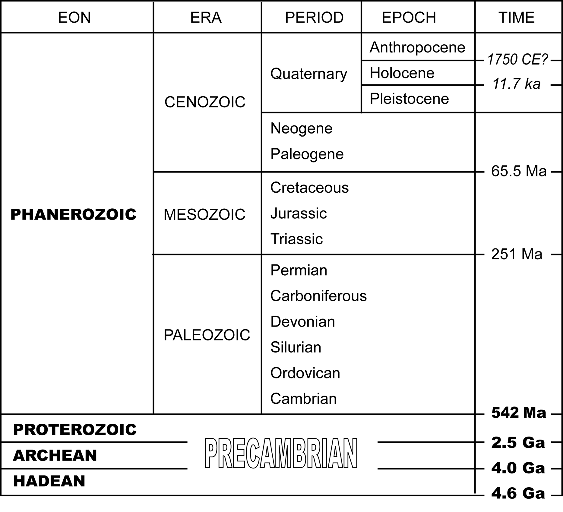
Table 1.1. The geological timescale
- CE stands for Current Era, which replaces A.D.
- 1 ka = one thousand years (kilo-annum)
- 1 Ma = 1 million years (mega-annum)
- 1 Ga = 1 billion years (1000 million years, giga-annum)
The geological timescale in Table 1.1 is based on the 2009 International Stratigraphic Chart, published by the International Commission on Stratigraphy. The geological timescale is updated periodically to refine the definition of boundaries, to change the absolute dates fixed to boundaries, or to reorganize the subdivisions. Therefore, other representations of the timescale may not match Table 1.1 perfectly. At times, geologists have to make adjustments when a geologic time period is adjusted or a period gets a new name. The most recent revision to the geological timescale includes some substantial changes. You may discover that some of the details of Table 1.1 differ from information in some of your other course materials.
1.1. Reconciling Old and New Geologic Timescales
The following points may require clarification as a result of updates to the geological timescale:
Precambrian gets demoted
In the past, Precambrian has referred to the time period before which macroscopic life forms (i.e., those you can see with the naked eye) had appeared on Earth. However, now that geologists know that macroscopic life appeared before the (former) boundary between the Phanerozoic Eon and the Precambrian, the new timescale has officially demoted Precambrian to a general term for describing pre-Phanerozoic time, and has subdivided the Precambrian into the Proterozoic, Archean, and Hadean Eons.
Carboniferous replaces Mississippian and Pennsylvanian
In the Paleozoic Era of the Phanerozoic Eon, the time after the Devonian Period used to include the Mississippian and Pennsylvanian Periods. These periods lost favour because they referred specifically to rocks in the United States: the division between the two periods is not internationally applicable. Furthermore, outside of North America, the time represented by the Mississippian and Pennsylvanian periods was routinely referred to as the Carboniferous Period, in reference to the global distribution of coal-forming swamps. Eventually, Mississippian and Pennsylvanian Periods were officially combined into the Carboniferous Period. The Mississippian and Pennsylvanian Periods do appear in the legend of your Whiterabbit Creek Map.
The Cenozoic Era has been renovated
The Cenozoic Era of the Phanerozoic Eon was previously divided into two periods: the Tertiary and Quaternary Periods. The Cenozoic Era now consists of three periods, as the Tertiary Period has been subdivided into the Paleogene and Neogene Periods.
A new epoch?
There is much discussion about adding an epoch to the Quaternary Period. Presently the Quaternary Period officially consists of the Pleistocene and Holocene Epochs. The Holocene Epoch is the time since the last ice age, now defined as 11,700 years ago (11.7 ka). Since 2000, geologists have referred informally to the Anthropocene to describe the time frame in which human activities have had a substantial effect on the Earth system. The start of the Industrial Revolution (approximately 1750 C.E.) has been suggested as the start of the Anthropocene, because this is when humans began releasing substantial amounts of CO2 into the atmosphere. The argument in favour of adding the Anthropocene is that the Earth system is likely to feel the impact of human activity over a geologically significant time interval, and that this impact will be evident in the rock record. According to Richard Alley, professor at Pennsylvania State University, “In land, water, air, ice, and ecosystems, the human impact is clear, large, and growing. A geologist from the far distant future almost surely would draw a new line, and begin using a new name, where and when our impacts show up” (as cited by Berardelli, 2008).[1]
Learning Activity
Study the abbreviated geologic timescale in Table 1.1, and try to memorize it. Without referring back to the table, complete Table 1.2 below. You may find it helpful to construct your own mnemonic device (a memory tool) to assist you with this task. For example, if you associate the first letter of each period of the Paleozoic Era with a word, you might come up with a sentence like “Clearly, orangutans should do community policing.” The stranger, the better!
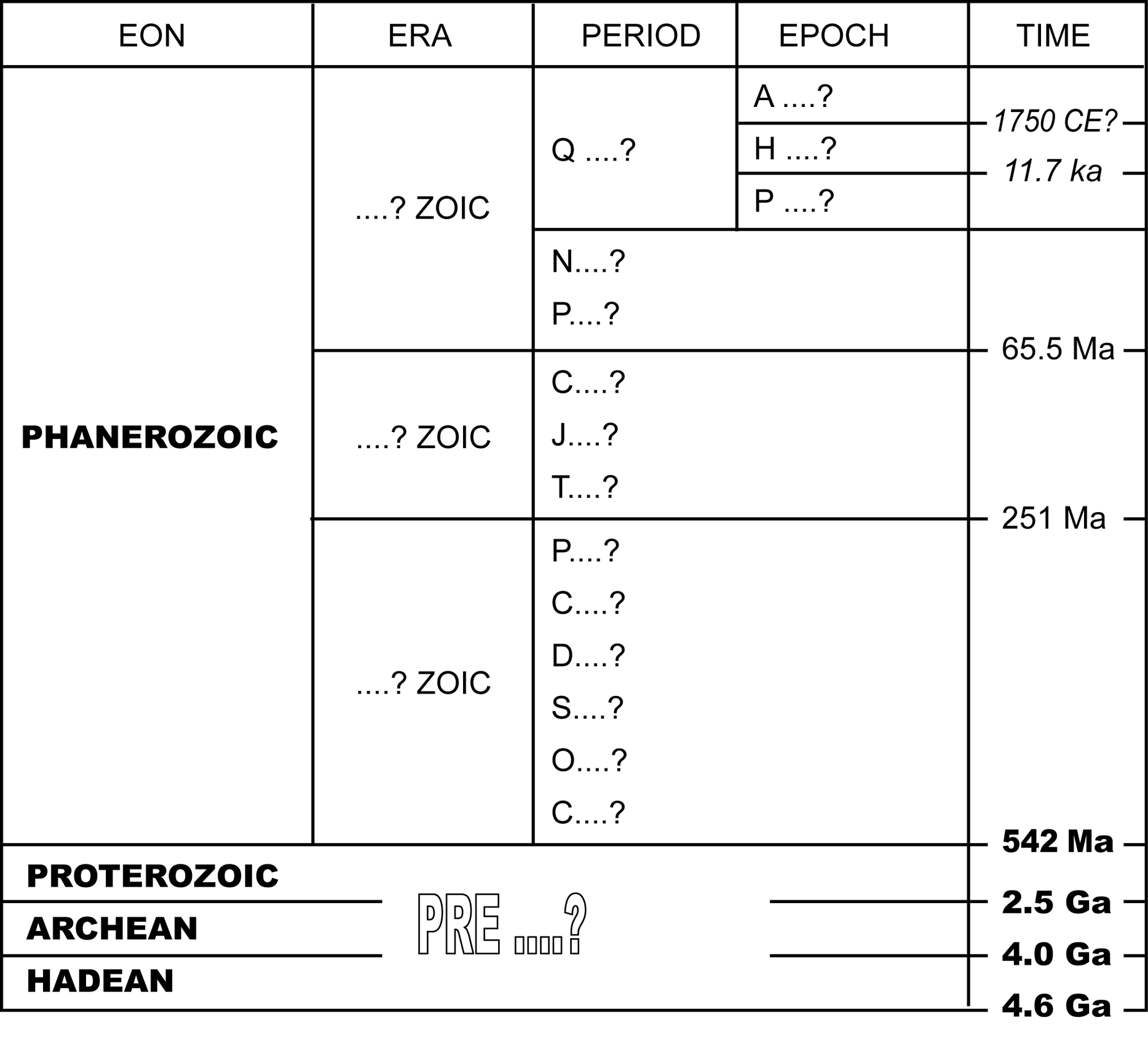
Table 1.2. The geological timescale: practice version
Lesson 2: What Is Structural Geology?
Structural geology studies the shaping and reshaping of rocks by the geological forces acting on them. For example, consider the process of lithification, in which loose sediments are turned into hard rock. Lithification begins with compaction, whereby loose sediments are changed by the weight of newer sediments accumulating above them. The spaces between sedimentary particles get smaller, fluids within those spaces are squeezed out, and the particles may change shape or orientation. Even tiny crystals within those particles may reshape themselves to accommodate the downward force. When looking at the rock after it has undergone compaction, clues such as pebble alignment or the direction in which crystals have grown will indicate that a downward force was applied. In structural geology, geologists study the effects of geological forces on the shapes of rocks to figure out the nature of those forces and how they contributed to the shape and structure of the Earth's crust.
Geologists are frequently confronted with situations that are far more complex than the case of compaction described above. A rock may have experienced different kinds and amounts of force applied from different directions at different times in its history. The effects on the rock might be microscopic, such as the alignment of mineral crystals, or the effects might be visible over thousands of kilometres, such as mountain ranges along the edges of newly forming continents. Often, both microscopic and macroscopic effects are present. In this case, a geologist needs to know as much as possible about how rocks react when force is applied. The clues in the rocks may help us find resources such as oil or minerals, they may explain the scenery you see out your window, or they may recount the story of how billions of years of geologic change has situated continents and oceans.
Reading Assignment
- Read Davis, Reynolds, & Kluth: “Motivation and Context” to the end of “Deformation, An Outcome of Stress vs. Strength” (pp. 2–15)
2.1. Geological Structures
In general, the shapes and features of rocks that provide clues about the rocks' histories are referred to as geologic structures. Table 1.3 (below) lists a variety of geological structures. In this course you will learn about these many structures. You may wish to draw a similar chart for yourself on a much larger scale, to keep brief notes on what you learn and to organize your knowledge. Right now, however, we will look at this table in a general way.
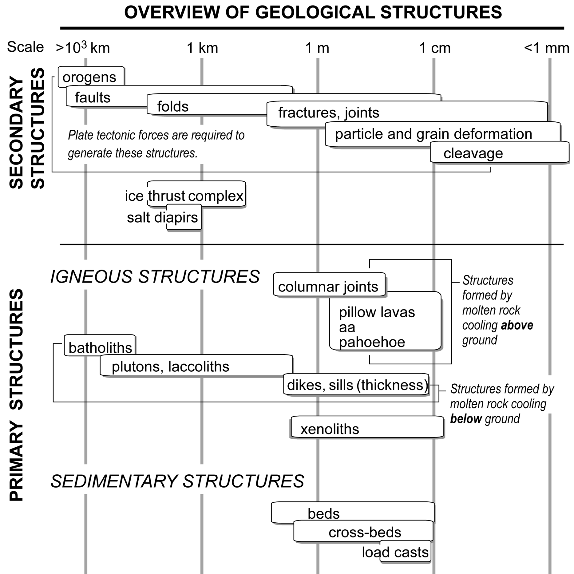
Table 1.3. Overview of geological structures
First, examine the top of Table 1.3, and note the range of length scales. As we have discussed, some structures are microscopically small, whereas others are continent-sized. Next, look at the two broad classifications on the left side of the diagram: primary structures and secondary structures.
Primary structures, which develop while the rock is being formed, supply information about the environmental conditions that existed at the time of formation. The primary structures, listed in the lower part of Table 1.3, are further subdivided into igneous structures and sedimentary structures, according to rock type.
Igneous structures form when molten (i.e., melted) rock cools. When molten rock reaches the surface of the Earth and begins to cool above ground, the structures that form are determined by how the lava flows and how it cools. When molten rock cools within the interior of the Earth, the masses of rock that are formed are classified by their size and shape.
Molten rock that reaches the surface of the Earth is called lava. When lava cools, the rocks that form are called volcanic rocks, or extrusive igneous rocks. (Hint: Extrusive igneous rocks form after they exit the interior of the Earth.) Molten rock in the interior of the Earth is called magma. Magma cools to form intrusive igneous rocks inside the Earth.
- In rocks that are formed from small particles accumulated by wind, water, or ice, sedimentary structures affect the arrangement of grains within the rock or the shapes of beds.
Secondary structures develop when force is applied to pre-existing rocks. In other words, secondary structures tell us about the forces that acted upon a rock after it formed. Secondary structures provide information about how rocks came to be situated where they are, and about the history of forces that acted upon them.
Reading Assignment
- Read Davis, Reynolds, & Kluth: “Architecture and Structural Geology” (pp. 16–18)
- Read Davis, Reynolds, & Kluth: “The Fundamental Structures” (pp. 21–29)
Study Questions
- Briefly define structural geology.
- What is deformation of rock?
- Which rock types are deformable? Which ones are not?
- What causes structural deformation of a rock, and how does temperature affect the ability of a rock to resist deformation?
- What is the difference between primary and secondary structures?
Lesson 3: Plate Tectonics
Secondary structures, especially those present on a regional scale (over tens of kilometres and greater distances), are created by the enormous forces resulting from the movement of Earth's fragmented outer layer. These fragments are called plates, and their behaviour is described by plate tectonic theory. The modern theory of the movement of lithospheric plates is the starting point for explaining a wide range of geological phenomena, such as mountain building, volcanoes, and earthquakes. However, plate tectonic movement is also fundamental to the mechanisms that cause global warming and ice ages. Plate tectonics can determine whether the interior of a continent will be a desert or a rainforest, and can even drive the extinction of species. Plate tectonics is a very powerful theory.
3.1. Tectonic Plates
The Earth is made up of layers with different mechanical properties. These layers have different strengths and respond differently to forces, which leads to the interaction of tectonic plates. The rigid layer that is broken into plates is called the lithosphere (Fig. 1.1a). The uppermost part of the lithosphere, called the crust, is brittle. Lithosphere is classified as either oceanic or continental, depending on the composition of its crust. Oceanic lithosphere is thinner than continental lithosphere, and has a higher density. Lithospheric plates float on a non-rigid layer called the asthenosphere. Over long time periods, the asthenosphere deforms by flowing, permitting the lithospheric plates to move.
Figure 1.1. (a) Tectonic plates, consisting of oceanic and continental lithosphere, comprise a thin shell of material compared to the total volume of the Earth (b).
The boundary between the crust and the rest of the lithosphere (indicated by the dotted line in Fig. 1.1) is called the Mohorovičić discontinuity (Moho for short). When geologists first began to study the structure of the interior of the Earth, they found that seismic waves were deflected at the Moho. This was convincing evidence that the Moho marked the bottom of tectonic plates. As a result, the Moho was used to define a boundary between the crust and the next layer within the Earth, the mantle. We now know that the Moho marks a change in the composition of rocks, but that it is usually located well within the tectonic plates.
3.2. Plate Margins
The importance of plate tectonics for structural geology is in the interaction of plates along their margins, or boundaries.
Divergent plate boundaries: At divergent plate boundaries, the plates move away from each other. These boundaries are also referred to as spreading centres, or rift zones. At divergent boundaries in the ocean (see the region of Fig. 1.3 labelled “MID-OCEAN RIDGE”), new oceanic crust is formed as the plates move away from each other and molten rock wells up from the mantle to take up the space. These regions are called mid-oceanic ridges (MOR) because they result in the formation of long underwater mountain chains along the rift zone. Rift zones also develop within continents, and cause the continents to split apart. Initially, the rift manifests as a thinning of the continental crust, forming rift valleys. The crust becomes so thin that it is infiltrated by molten rock from the mantle, and eventually new oceanic crust is added to the margins of the continent.
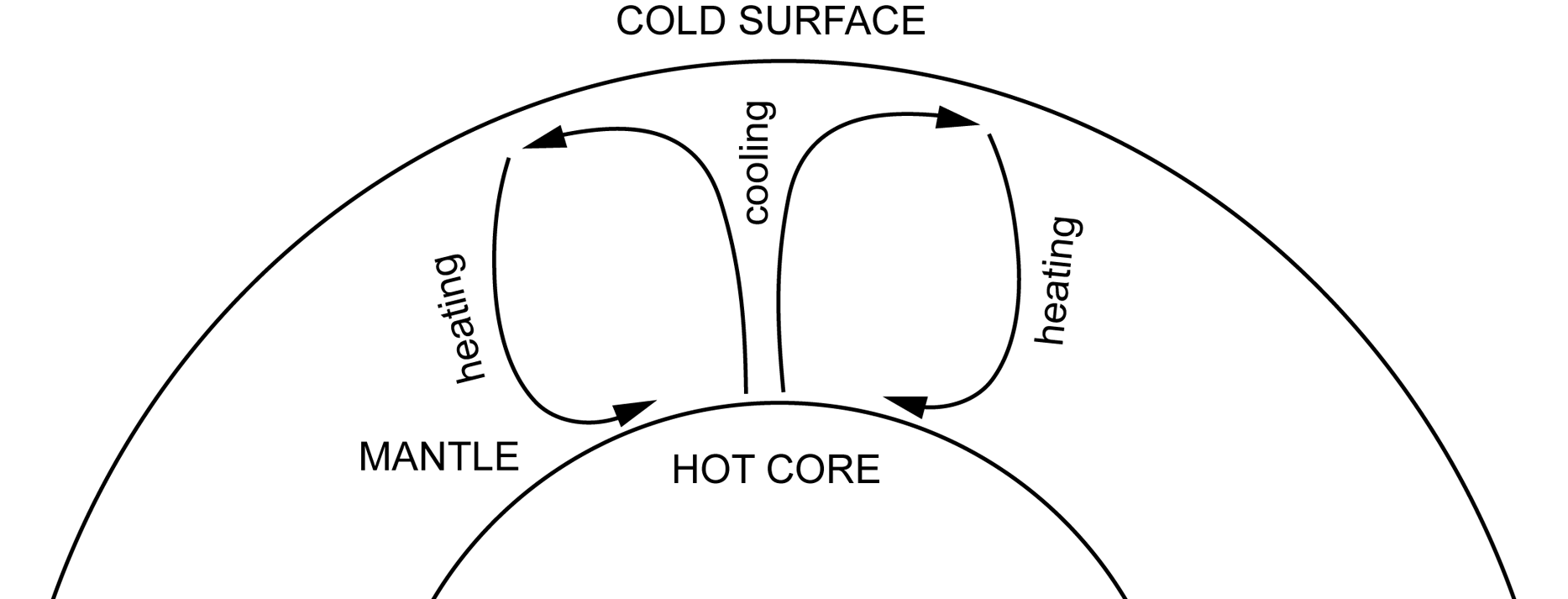
Figure 1.2. Mantle convection within the Earth
Rifting is thought to be related to convection within the interior of the Earth (Fig. 1.2, above). Material heated by the Earth's hot core is less dense than material closer to the surface, where the Earth is cold by comparison. The heated material rises, but loses its heat as it reaches the lithosphere. When it cools, its density increases, and it sinks towards the core. Rift zones are thought to occur where hot upwelling mantle material weakened a lithospheric plate, eventually splitting it.
In the past it was thought that flow within the mantle supplies the “push” to move the plates apart from each other. Now we know that gravity contributes much more to plate motion that does mantle flow. Gravity acts in two ways: one is that it drags the subducting slab into the mantle, pulling the rest of the plate along with it. This is called slab pull. The other way gravity acts is on mid-ocean ridges. At the ridges the oceanic lithosphere is higher up than elsewhere on the plate The elevated lithosphere falls “downhill,” away from the spreading centre, “pushing” the plate along. This is called ridge push.
Transform boundaries: At transform boundaries, the plates slide past each other. Transform boundaries (also called transform faults) are very common along mid-oceanic ridges, where they offset segments of divergent margin.
Convergent plate boundaries: At convergent plate boundaries, the plates move towards each other. The enormous collisions that occur along convergent plate boundaries produce the forces responsible for many of the structures we will study. Much of this course will focus on convergent plate boundaries, because this is where continents are built.
When a plate boundary consisting of oceanic lithosphere collides with another plate boundary, one of the plates is forced beneath the other and back into the mantle. The region where this happens is called a subduction zone (Fig. 1.3, below), and the piece of lithospheric plate that is forced back into the Earth is called a subducting slab. A trench marks the location where the slab is being subducted. The boundary of a plate of continental lithosphere that is colliding with a plate of oceanic lithosphere is called an active margin. A transition from continental lithosphere to oceanic lithosphere where there is no tectonic activity is called a passive margin.
The subducting slab carries with it sediments that have accumulated on the ocean floor, and these sediments contain water. Once within the earth, the sediments release the water into surrounding rocks. The water decreases the melting point of these rocks, causing magma to form and to find its way to the Earth's crust, where a volcano may release the molten rock in a volcanic eruption (see Fig. 1.3). As such, subduction zones are often marked by chains of volcanoes. A chain may be a series of volcanic islands in the ocean (a volcanic island arc), such as the Aleutian Islands, or Indonesia. Alternatively, a chain of volcanoes can be on continental crust, such as the Cascade Range in North America, which contains Mt. St. Helens.
Sedimentary and volcanic materials are shed from volcanic islands and from continental margins. Figure 1.3 illustrates several different depositional settings.
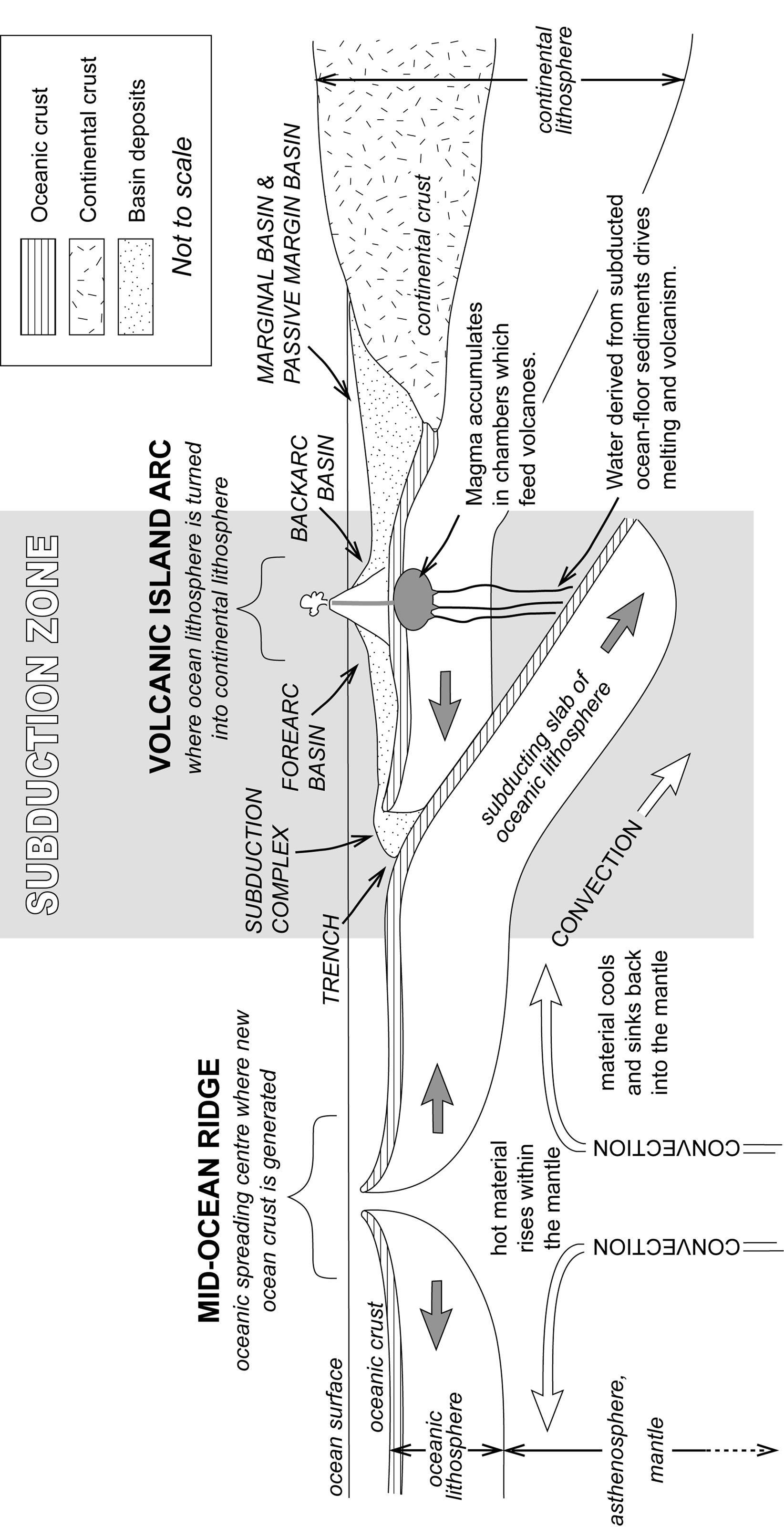
Figure 1.3. Oceanic lithosphere margins
The subduction complex consists of sedimentary and/or volcanic material that partially fills the trench. The forearc basin is present between the volcanic island arc and the trench, and the backarc basin is present on the side of the volcanic island arc that faces away from the trench.
Sediment shed from the continent fills a marginal basin. The transition between continental lithosphere and oceanic lithosphere in Figure 1.3 does not involve a subduction zone, so the continental margin is a passive margin. This basin can be referred to more specifically as a passive margin basin.
Note that not all convergent plate boundaries form subduction zones and volcanoes. Neither of these occur when the colliding plates are both made of continental lithosphere. Continental lithosphere is less dense than either oceanic lithosphere or the asthenosphere beneath. Therefore, when continental lithospheric plates collide, they form a very large “crumple zone,” but no subducting slab. One such crumple zone consists of the Himalayan Mountains, in which Mt. Everest is located, and the Tibetan Plateau.
Reading Assignment
- Read Davis, Reynolds, & Kluth: “Plate Tectonics and Structural Geology,” (pp. 18–21)
Study Questions
- What is the difference between an active margin and a passive margin?
- Compare and contrast the characteristics of oceanic and continental lithosphere. What accounts for the different behaviour of oceanic and continental margins in collisions?
- Compare and contrast the characteristics of the lithosphere and asthenosphere. What role does each play in plate tectonic theory?
- What are divergent plate boundaries, and how do they differ from subduction zones?
- Why do tectonic plates move?
- What happens when a denser plate is fed into a subduction zone?
Lesson 4: Orogeny: Building Continents with Colliding Plates
Oceanic lithosphere is created at mid-ocean ridges, but where does continental lithosphere come from? What process makes lithosphere that is thicker, but less dense than oceanic lithosphere? Actually, continental lithosphere starts out as oceanic lithosphere. In fact, island arc volcanism is the first stage in a long series of events that slowly change oceanic lithosphere into continental lithosphere.
The key change process is the infiltration of magma into the lithosphere. This magma will eventually freeze and thicken the lithosphere. Furthermore, progressive remelting and refreezing of the lithosphere produces rocks that become less and less dense. Eventually, the modified lithosphere will become less dense than unmodified oceanic lithosphere, so that when modified (now continental) lithosphere collides with oceanic lithosphere, the oceanic lithosphere will be subducted, but the continental lithosphere will not.
Although volcanism may start the continent-forming process, it is not the only way by which continents grow. Recall the depositional basins discussed in the previous section. An active-margin basin develops at or near a colliding plate boundary where oceanic lithosphere is subducting under continental lithosphere (see Fig. 1.4a, below). Within the basin, sediment shed off the adjacent continent accumulates. Material in an active or passive margin basin can eventually accumulate to a far greater thickness than the depth of the ocean in which the deposits formed, because the weight of the accumulating material causes the lithosphere to “sag” into the asthenosphere. This process is called isostatic sinking. Isostatic sinking ensures that there will always be room for more sediments to accumulate. Additional space can be added to parts of an active margin basin closer to the subduction zone as the plate containing continental lithosphere is dragged downward by the force of friction between it and the subducting slab. This is called subduction down-pull. The result is that a basin that may have had a water depth of 6 km will accumulate more than 20 km of sediment. The depositional basins associated with continental margins, whether active or passive, are referred to as geosynclines (see Fig. 1.4a). More specifically, the part of a geosyncline that is deposited on oceanic crust is called a eugeosyncline (or eugeocline), and the part of the geosyncline that is deposited on continental crust is called a miogeosyncline (or miogeocline).
As the plates continue to collide, the active-margin geosyncline shortens progressively. The rocks it contains become deformed, the deep parts of the geosyncline are forced even deeper, and the upper parts are squeezed upward. As a result, the geosyncline is transformed into a tectonic mountain belt, or orogen, adding to the existing continental crust (see Fig. 1.4b). The process of compressing and deforming the geosyncline is referred to as orogeny. The part of the continental crust that remains undeformed, or stable, during the orogeny is referred to as a craton. If some of the miogeoclinal sediments escape the orogeny, they may be preserved as a platform deposit between the orogen and the craton.
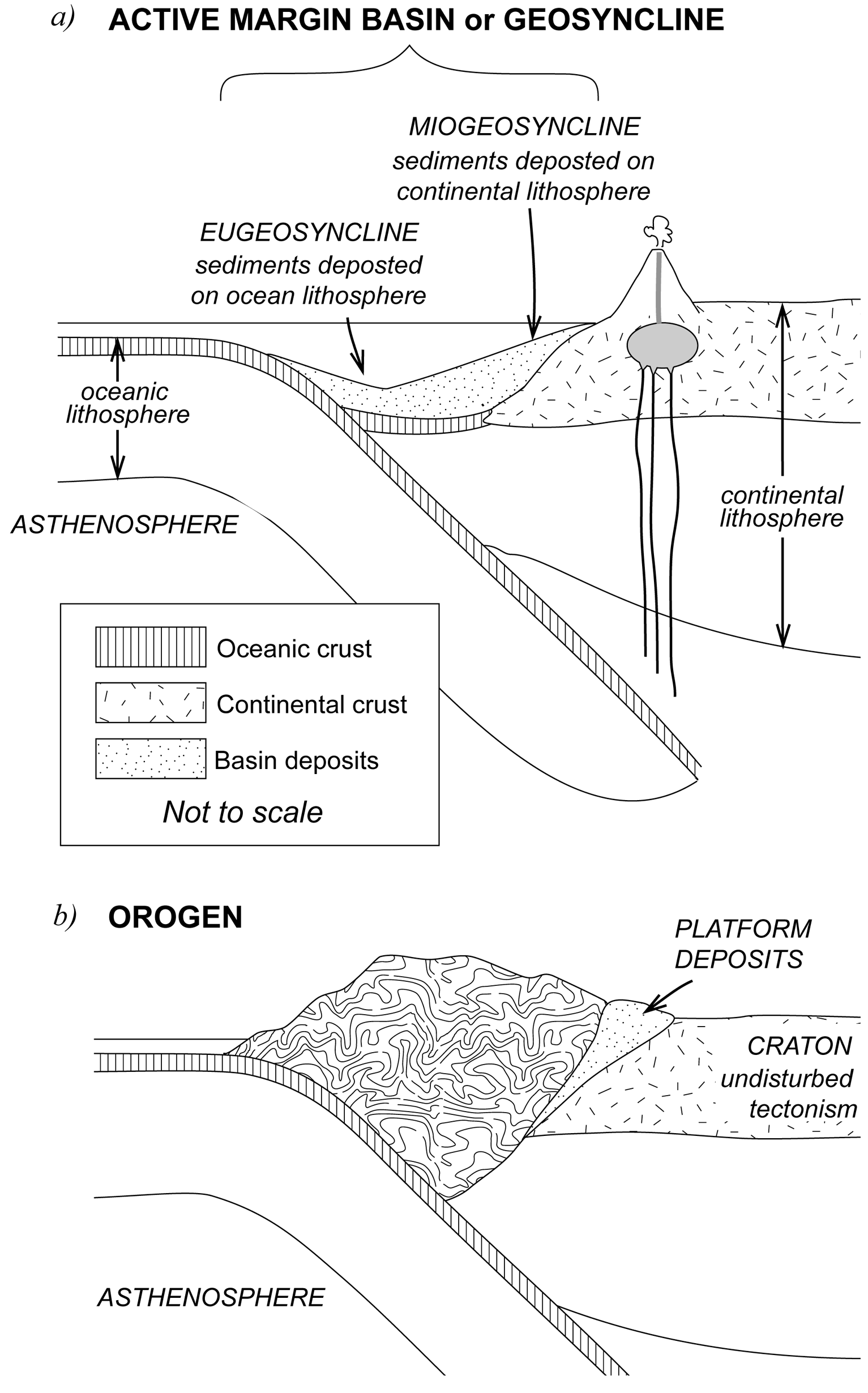
Figure 1.4. Development of an orogen
This newly-formed orogen itself will then be eroded and contribute to the formation of a new geosyncline. Then, as the geosyncline is deformed, the orogen will act as a craton to yet another new orogen.
Exotic Terranes
When an ocean lithospheric boundary collides with a continental lithospheric boundary, the oceanic lithosphere is fed into the subduction zone like a conveyor belt. This oceanic lithospheric conveyor belt carries structures such as sea-floor volcanoes, volcanic rocks accumulated on the sea floor, sediments, and even parts of other continents. From time to time, however, the conveyor belt gets “jammed.” Instead of being dragged down into the subduction zone, these structures sometimes become stuck onto the leading edge of the developing orogen, forming exotic or accreted terranes. Sometimes it is unclear whether part of an orogen formed in situ, or formed elsewhere and was transported to the orogen by the oceanic lithosphere conveyor. Such terranes are referred to as suspect terranes.
Summary
Over the last four Ga, continents have grown by the continued operation of these processes, collectively known as continental accretion. In summary, new volume is added to continents by
- volcanism, derived from the melting of the mantle and ocean-floor crust;
- redistribution of material by erosion and sedimentary deposition, eventually ending in the formation of a new orogen; and
- accretion of terranes transported by subducting oceanic lithosphere.
Study Questions
- What is a terrane?
- How does the nature of the lithosphere influence the shape of the mountain belt produced when continents collide?
Lesson 5: Isostasy: The Ups and Downs of Orogens and Cratons
Orogeny has occurred intermittently on all continents, in almost every part of the continental crust. It has affected rocks of all types and ages. An individual orogeny may last for about 100 million years. The resulting uplift, along with millions of years of erosion, has produced Earth's major mountain belts and its most rugged and beautiful scenery.
5.1. Orogen versus Mountain Belt
There is a difference, however, between an orogen and a mountainbelt. An orogen is a segment of the Earth's crust deformed by compression, whereas a mountain belt is any region that is topographically high and rugged, regardless of how it was formed. All orogens are mountains to begin with, but these mountains eventually wear down by erosion. Older orogens have mountains that are less topographically impressive than younger orogens. Truly ancient orogens only retain the roots of mountains—you might never know from walking over them that they were once towering peaks.
Not all mountains result from orogenically produced uplift, however. In other words, not all mountains are formed from crumpled and folded rocks. Some of the mountains associated with convergent plate margins are volcanic in origin, as discussed in the previous section. The Pacific Ring of Fire is so named because the Pacific Ocean is rimmed by active volcanic belts, including intermittent chains of volcanoes from the southern tip of South America to Alaska, the volcanic Aleutian Islands, as well as Japan, the Philippines, and the East Indies. Volcanoes can also occur in geologic settings not related to convergent margins. Examples include Hawaii, Iceland, and the Canary Islands.
5.2. The Role of Isostasy
On the Earth's surface, we can find rocks that were once deeply buried in the roots of ancient mountains. How did those rocks make it to the surface? You might say that the rocks were exposed after erosion removed the rocks above them. This answer would only be partly correct, however. In many cases, the rocks that are exposed now come from many kilometres deeper within the Earth than the rocks you would see if you planed the mountains flat.
Upward movement of rock also occurs because of a state of floating equilibrium called isostacy, by which the outer shell of the Earth floats on the mantle rather than sitting rigidly upon it. This relationship between the lithosphere and the asthenosphere could be likened to that of a block of wood floating on water rather than sitting rigidly upon another block of wood. Placing a second block of wood on top of the first floating block would cause the first block to sink deeper into the water. If the second block of wood were removed, the first block would float higher in the water. Similarly, when the orogen thickens or when the lithosphere is loaded down with sediment, volcanic material, or a glacier, the lithosphere is depressed deeper into the asthenosphere. This process is called isostatic sinking (also isostatic loading, or isostatic depression). When material is eroded, or a glacier melts, the lithosphere undergoes isostatic rebound (or isostatic uplift), whereby it floats higher in the mantle. Therefore, deeply buried rocks are eventually exposed at the Earth's surface because, as erosion takes place, the lithosphere floats higher and higher in the mantle, permitting further erosion.
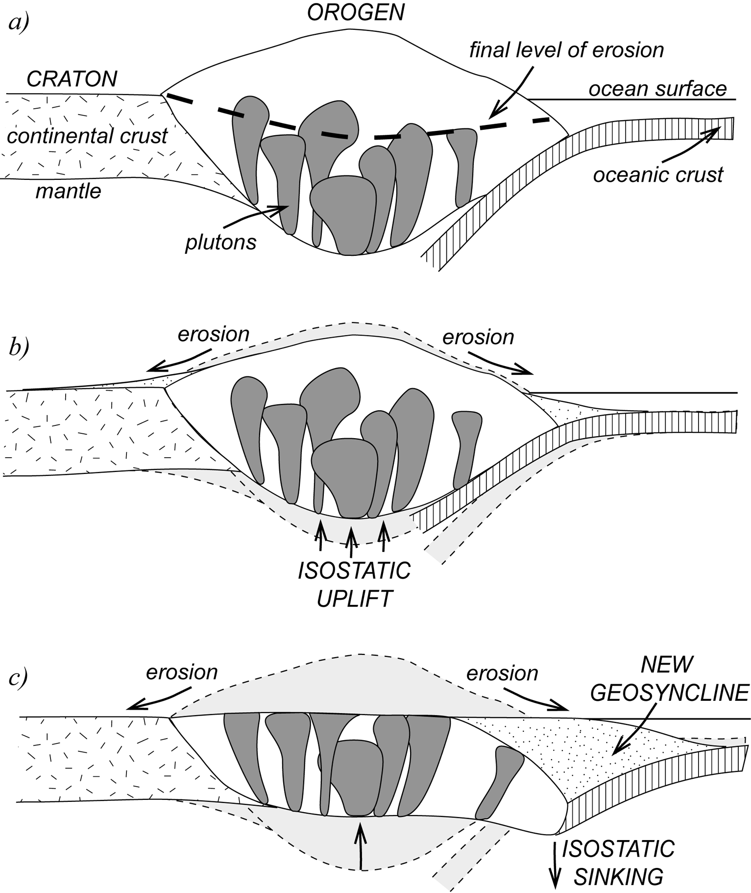
Figure 1.5. (a) A new orogen is slowly eroded from the top and lifted from the bottom by isostasy (b) until only the roots remain (c).
Isostatic uplift and erosion of an orogen is illustrated in Figure 1.5, above. The heavy dashed line in Figure 1.5a shows the final level of erosion, originally some 10-30 km below the Earth's surface. The orogen contains plutons, intruded principally into the lower two-thirds of the orogen, which are derived from melting of both the deepest parts of the orogen and the upper mantle. Over time, material from the top of the orogen is eroded away, decreasing the height of the mountain belt (Fig. 1.5b). At the same time, because the mass of the orogen is decreasing, the orogen floats higher and higher in the mantle. Eventually the plutons—once at the base of the orogen—are exposed (Fig. 1.5c).
A large part of the material eroded from orogens is deposited in geosynclines (Fig. 1.5c). The increasing mass of sediment in the geosyncline results in isostatic sinking, allowing a thick accumulation of sediments.
Study Questions
- What is the difference between a mountain belt and an orogen?
- What is isostacy?
- What processes can result in isostatic sinking?
- What processes can lead to isostatic uplift?
Lesson 6: Early Development of the North American Continent
The next reading is a scientific paper that summarizes the research on how North America was assembled prior to Phanerozoic time. This kind of summary paper, called a review, is a good place to start on this topic, because a review contains a large amount of relevant research in one place, and it outlines the important questions and debates. This paper also contains a large set of colour illustrations, showing step-by-step how the oldest parts of the North American continent came together.
This paper will form the basis of the theory portion of your assignment for this unit. The assignment questions are designed to guide you to the main points of the article, which are important for understanding how the North American continent formed. The questions are also intended to give you practice with skimming techniques. You can find more information on reading scientific papers, along with suggestions for skimming techniques in your Course Information.
Key Terms
Understanding the following terms, which appear in the paper, will make it easier to find the information you need for your Unit 1 assignment.
- coeval: originating, developing, or occurring at the same time
- diachronous: occurring at different times
- granitoid: a general term for rocks containing the minerals quartz, feldspar, and micas, which are found in granite. Granitoids may or may not include actual granite. Granitoids are characteristic of continental crust, not oceanic crust.
- greenstone: metamorphosed basalt (basalt is the primary constituent of oceanic crust)
- juvenile: refers to rocks that consist of newly-formed materials, not fragments of older crust
- Laurentia: a name given to the ancestral North American continent
- pillow basalt: a structure formed when basaltic lava solidifies under water
- province: the geographic extent of a particular group of rocks (e.g., the Penokean Province contains rocks deformed during the Penokean Orogeny).
- quartzite: metamorphosed sandstone
- supercontinent: a single enormous continent made up of all the continents
- syntectonic: an event that occurs while tectonic activity is ongoing in a region
- turbidite: a sedimentary deposit created by underwater landslides
Reading Assignment
- Read Whitmeyer, S. J., and Karlstrom, K. E. (2007). Tectonic Model for the Proterozoic Growth of North America. Geosphere 3(4), 220-259. doi:10.1130/GES00055.1
Study Questions
- When and how did the Canadian Shield form? What other continents were involved in this process?
- What type of mantle lithosphere underlies North America today?
- How did the lithosphere of the southern part of North America form?
- What structures demarcate boundaries of individual terranes in the accretionary provinces?
- What process helped transform juvenile crust into stable continental lithosphere as terranes were added to the North American continent?
Assignment 1
You should now complete the theory portion of Assignment 1, which you can find in the assignment drop box. You will submit this assignment to your tutor for grading after you have also completed the lab portion.
Answers to Study Questions
Lesson 2
- Structural geology is the study of the deformation of Earth's crust.
- The deformation of rock describes structural changes that occur to a rock's location, orientation, shape, and volume. Deformation also refers to the chemical and physical processes that cause the structural modifications and to any geologic structures that may form as a result of the deformation.
- Any rock type can be deformed given the appropriate conditions.
- Structural deformation occurs when stresses in the Earth's crust exceed the rock's strength. At elevated temperatures, rocks are more likely to behave in a ductile manner because molecules can stretch and move. Hence, at higher temperatures, less stress is required for rock to deform. At lower temperatures, however, rocks are more rigid and are more likely to be brittle.
- Primary structures form during the formation of a given rock. Examples include depositional structures that form in sedimentary rocks as sediments are being deposited. Structures that form in molten lava before it solidifies also result in primary structures. Secondary structures are those structures that form after the solidification or formation of the rock.
Lesson 3
- Margin refers to a transition between continental and oceanic lithosphere. An active margin is one that coincides with a plate boundary, where plate movement and processes such as earthquakes, volcanic activity, and plate subduction occur. A passive margin is one where there is no tectonic activity or plate movement.
- Oceanic crust is typically basaltic (mafic) in composition. It ranges in thickness from about 4-9 km. Continental crust, on the other hand, is largely felsic (granitic or andesitic) and can range in thickness from 25-75 km. Mafic rocks have a density of about 2.9 g/cm3, which is significantly higher than that of felsic rocks (2.7 g/cm3). Hence, when an oceanic plate collides with a continental plate, the oceanic plate is subducted beneath the less dense continental plate.
The lithosphere is the “rigid” uppermost concentric layer of the Earth. It comprises the crust (both continental and oceanic) and the uppermost part of the mantle. Under the oceans, the lithosphere has an approximate thickness of about 70 km, while under continental crust, the lithosphere is believed to reach approximately 225 km. The rigidity of the lithosphere enables it to withstand limited quantities of differential stress for indefinite periods of time without deforming by flowing. In the theory of plate tectonics, tectonic plates comprise the lithosphere.
The asthenosphere comprises the upper mantle material that underlies the lithosphere. Beneath the oceanic crust, the asthenosphere is believed to reach thicknesses of up to 630 km, whereas under the continental crust, the asthenosphere is about 475 km thick. A major distinguishing characteristic between the asthenosphere and the lithosphere is that the asthenosphere can flow continuously even under low levels of differential stress. This is why tectonic plates can move freely. An important factor to note is that the transition between the lithosphere and the asthenosphere is actually not a compositional one—it is simply a result of differences in ductility between the two.
Divergent plate boundaries are zones where crustal plates move apart. Such regions are characterized by upwelling basaltic magma at spreading submarine ridges. Typically, as fresh magma comes up to the surface, segments of crust formed earlier move outwards laterally on either side of the ridge to form new oceanic crust. Thus, the crust displays a symmetrical increase in age with distance from the ridge.
Conversely, convergence zones are regions where plates meet or collide. Depending on the nature of the plates that are coming together, convergence can result in subduction, which is when oceanic crust that has cooled is forced downwards, causing it to sink into the mantle. Therefore, subduction zones occur at convergent plate boundaries.
- At present the gravity-driven mechanisms of ridge push and slab pull are widely accepted as the main causes of plate motion. In the past, mantle convection and Earth's rotation were also considered as important drivers of plate motion. For a more detailed discussion, see the Wikipedia page on “Driving Forces of Plate Motion.”
- When a (denser) plate descends into a subduction zone, friction generated by its downward movement can result in a significant level of seismic activity down to depths of about 700 km. This area of deep, active seismic activity is called a Benioff zone. Trenches mark the point where the subducted crust flexes downwards. The high pressure and low to moderate temperatures that characterize the conditions beneath the subduction zone result in blueschist metamorphism. As the subducting slab continues to descend, it reaches temperatures at which volatiles are released from the downward moving slab. These volatiles rise and cause partial melting of the mantle material above them, generating magma in the process. The magma may then rise to form volcanic arcs.
Lesson 4
- A terrane is a fragment of crustal material that originates on one tectonic plate but is transported laterally, ending up as an accretion on the crust of another tectonic plate. The fragment preserves its own geology, which distinguishes it from the plate on which it has become sutured. For this reason, the term exotic terrane is sometimes used.
- Where the lithosphere is strong, the mountain belt resulting from collision (orogenic belt) will be narrow and tall. With a weak lithosphere, however, broad and low orogenic belts form. The length of the contact zone determines the length of the orogenic belt.
Lesson 5
- The term mountain belt refers to any elevated and rugged portion of the Earth's crust, without reference to how it was formed. An orogen (or orogenic belt), on the other hand, is a mountain belt resulting from the collision of tectonic plates.
- Isostacy refers to the process of gravitational equilibrium that operates between the lithosphere and the asthenosphere. Through isostacy, tectonic plates are dynamically maintained at elevations that depend on their thickness and density, as if they are floating on the asthenosphere.
- Isostatic sinking occurs when a load is placed on part of the Earth's crust. Examples include the deposition of large quantities of sediment in a sedimentary basin, accumulation of volcanic material in a given basin, glacial loading by accumulation ice, and the thickening of the Earth's crust through orogenic processes.
- Isostatic uplift can occur when a load or weight that previously existed on a part of the Earth's crust is removed. Examples of such unloading include erosion of crustal material or the melting of a glacier.
Lesson 6
- The Canadian Shield, which forms the core of the North American continent, emerged about 2.0-1.8 Ga (or billion years) ago, during the Paleoproterozoic period, as a result of collisions of continents dating from the Archean period. The continents that collided included Slave, Rae-Haerne, and Superior, as well as smaller continental fragments, including Wyoming, Medicine Hat, Marshfield, and Nain. These collisions resulted in the Trans-Hudson orogen. Between the amalgamated crustal segments of Archean origin are younger (juvenile) volcanic zones.
- The mantle lithosphere that underlies the North American continental crust is thick, buoyant, and largely Archean (age). Compositionally, it is depleted (depletion refers to the content of incompatible elements such Rb, U, and rare-earth elements that are removed from the peridotite mantle during crustal formation).
- The southern part of the North American continent was formed by the accretion of volcanic arcs of juvenile age and oceanic terranes along the plate margin on the southern edge of the continent. Early fusions included Pembine-Wausa and Elves Chasmarcs, which accreted around 1.84-1.82 Ga ago (a time period when the Canadian Shield was still being formed). By 1.8 Ga, the core of the North American continent was essentially complete. Subsequent additions to the continent were by arc-continent accretion.
- Accretionary provinces comprise terrane blocks ranging in size from 10-100 km. Shear zones demarcate the boundaries between individual terrane blocks.
- Between ca. 1.80-0.95 Ga, a series of orogenies, which included the Yavapai orogeny (1.71-1.68 Ga), the Mazatzal orogeny (1.65-1.60 Ga), the Granite-Rholite province (1.45-1.30 Ga), and the Llano-Grenville province (1.30-0.95), resulted in the accretion of additional material to the North American continent. In each of these episodes, whenever additional juvenile lithosphere was added, extensive granitic plutons also formed. These plutons helped to weld the orogenic boundaries between the different orogenies, and this transformed the juvenile crust into durable continental lithosphere.
Footnote
[1] Berardelli, P. (2008, January 24). Human-driven planet: Time to make it official? ScienceNOW. American Association for the Advancement of Science. Retrieved from https://news.sciencemag.org/sciencenow/2008/01/24-01.html?rss=1