Geology 319 Structural Geology: The Architecture of Earth’s Continental Crust
Study Guide :: Unit 2
Basic Techniques for Interrogating the Rock Record
Overview
In Unit 2 you will learn how to determine and describe the geological history of a group of rocks, including the order in which the rock beds formed and the sequence of events, such as folding and faulting, that may have occurred afterward. Lesson 1 covers the principles of stratigraphy—the “rules of thumb” that geologists apply when attempting to create geological histories. It also covers gaps in the rock record, called unconformities. In Lesson 2 you will learn how primary structures in sedimentary rocks can be used to determine way-up, the direction in which rocks get younger. Lesson 3 covers way-up indicators in lava flows, and Lesson 4 covers way-up indicators in pyroclastic rocks.
Objectives
After studying this unit, you should be able to
- use the four principles of stratigraphy to interpret the geological history of a cross-section.
- explain what an unconformity is, list the three kinds of unconformities, and describe how they are different.
- explain what is meant by way-up.
- use sedimentary and volcanic way-up indicators to determine the stratigraphic facing of beds.
Lesson 1: Geological Histories
1.1. Principles of Stratigraphy
Geologists keep in mind four basic rules of thumb when they try to figure out the history of a particular group of rocks. These rules are called the principles of stratigraphy.
Sedimentary rocks are deposited in layers, called beds or strata. Sedimentary rocks include rocks whose particles were erupted from a volcano, such as volcanic ash. The surface shared between the top of one bed and the bottom of the next is called a contact.
- The principle of original horizontality states that beds form in horizontal layers. The bottom of the beds may be irregular if sediments have been deposited on an irregular surface, such the contact between beds A and B in Figure 2.1 below. Once the irregularities are covered, however, the top of the sediment layer will be basically horizontal (e.g., beds C and D, Fig. 2.1). This principle implies that if beds are not horizontal, something happened to them after they were deposited to disturb them from a horizontal position.
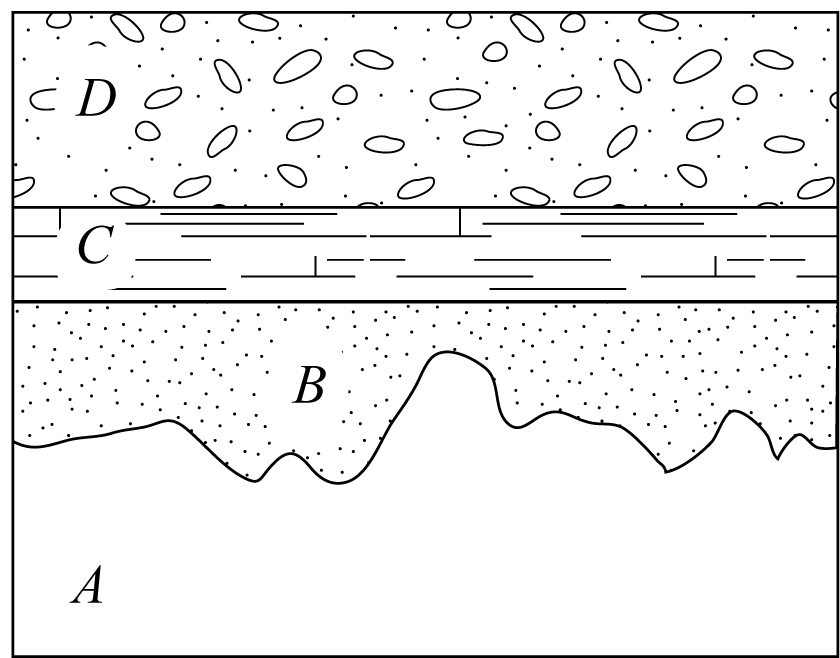
Figure 2.1. Principle of original horizontality
Figure 2.2. Principle of Superposition
The principle of superposition states that in a sequence of beds that has not been overturned, the beds get progressively younger from bottom to top. This is not unlike having a stack of books and papers on your desk. If you are looking for an item on your desk, the more recently you last handled it, the closer to the top of a stack you will look for it. Older materials are more likely to be at the bottom of piles, while more recent additions are likely to be near the top.
Taken together, these two rules permit us to say that the beds in Figure 2.2 were deposited in the order E, D, C, B, A, and that the beds were folded.
- The principle of horizontal continuity states that beds tend to extend laterally over long distances. Beds do not end abruptly—they either change composition slowly where there is a change in environment, or they become thinner and thinner until they “pinch out.”
- The principle of horizontal continuity is often used with the principle of cross-cutting relationships. This principle states that geologic features are always younger than the rocks or surfaces that they cut across. For example, in Figure 2.3 below, beds A through F appear to end abruptly. This is an indication that they are cut by a fault (H), which has moved beds C and D next to beds A and B. We assume the beds labelled C on each side of the fault (and D)are the same beds on either side of the fault, because we know that they should not end abruptly, and because they have the same composition, as indicated by the patterns. Sometimes a lot of evidence is required to demonstrate that offset layers are part of the same bed. Notice that there is also an igneous intrusion (G) that is not cut by the fault. From these observations, we can say that the beds in Figure 2.3 were deposited in the order F, E, D, C, B, A (superposition); faulting occurred along H (horizontal continuity,cross-cutting relationships); and intrusion of G occurred (cross-cutting relationships).
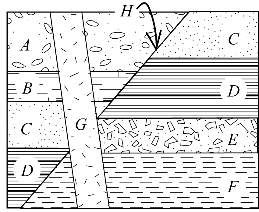
Figure 2.3. Principle of Cross-cutting relationships
1.2. Unconformities
Igneous intrusions and faults are two ways in which cross-cutting may occur. Erosion is another. The surface along which erosion has occurred or along which no sediments have been deposited for a geologically significant length of time is called an unconformity. Unconformities are gaps in the rock record that occur because part of the record has been removed (as with erosion), or because no record was created (as with non-deposition). The period of time for which the record is missing is called a hiatus.
We recognize three kinds of unconformities: angular unconformities, nonconformities, and disconformities. These unconformities are described in your textbook.
Reading Assignment
- Read Davis, Reynolds, & Kluth: “C. Mapping Contact Relationships,” up to “Intrusive Contacts: Magmatic” (pp. 697–700)
Study Questions
- Figure 2.4 (below) shows a geologic cross-section containing an example of each kind of unconformity. Find and identify each unconformity.
Write a geological history for the rocks in the cross-section in Figure 2.4.
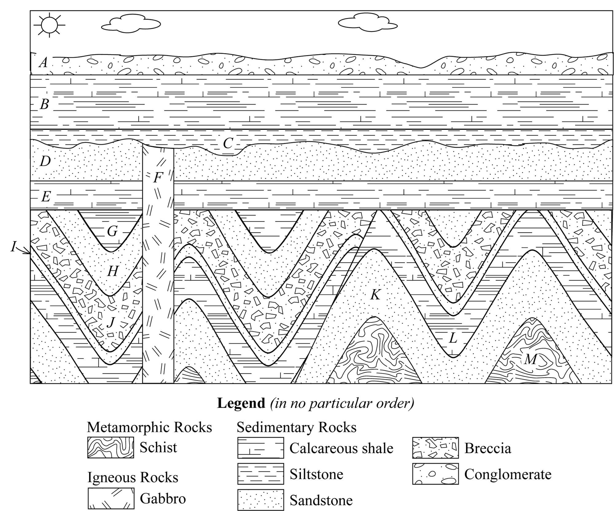
Figure 2.4. Practice cross-section
Fill in the blanks in the following sentences:
Nonconformities are depositional surfaces separating distinctly younger ______________ or ______________ rocks above from distinctly older ______________ or ______________ rocks beneath.
An angular unconformity is an unconformity that separates layers above and below that are not ______________. Classical angular unconformities are ______________ depositional surfaces separating relatively young ______________ strata above from older ______________ ______________ strata below.
A disconformity is an unconformity separating strata that are ______________ to each other.
For all three types of unconformity, the surface marking the unconformity is itself ______________ to the bedding or layering of the rocks above the unconformity.
Lesson 2: Primary Structures and Way-up in Sedimentary Rocks
Primary structures are formed before newly deposited material is transformed into rock. Primary structures are the result of deformation that occurs while the material is still in its original depositional environment (i.e., it has not been transported away from where it was first deposited). The deformation is caused by the same forces that were present when the material was deposited. This contrasts with secondary structures, which form as the result of stress applied to pre-existing rocks.
Primary structures can provide valuable information, such as
- the kind of environment in which the materials were deposited (e.g., in a river, or on the sea floor);
- the direction of flow of wind, water, or lava; and
- the direction in which sediments become younger.
This last bit of information is so valuable for interpreting the rock record that geologists have at least four different names for it:
- younging direction
- facing direction
- stratigraphic facing
- way-up
If there is certainty that a sequence of rocks has not been disturbed, then we know that the sediments get younger from bottom to top (principle of superposition). We would say that the rocks are facing upward, upward facing, younging upward, or are right-way-up. However, if sediments have been faulted and folded, way-up indicators provided by primary structures must be used to determine the younging direction. In fact, even if a sequence of deposits is flat-lying and seemingly undisturbed, it is good practice to check for way-up indicators to prove that the rocks have not been turned completely upside-down. In the following discussion, we will look at primary way-up indicators in three kinds of rocks: sedimentary (lithified or not), lava flows, and pyroclastic rocks. On diagrams, way-up is often indicated by a double arrow (⇑).
Way-up Indicators in Sediments and Sedimentary Rocks
2.1. Cross-stratification
Cross-stratification, or cross-bedding, refers to dipping or curving layers within an individual bed (see Figs. 2.5 & 2.6, below). A stratum with cross-stratification may be overlain or underlain by horizontal bedding or by more cross-stratified bedding (e.g., Fig. 2.6a). Note that the contacts of beds containing cross-stratification are normal bedding surfaces, not angular unconformities.
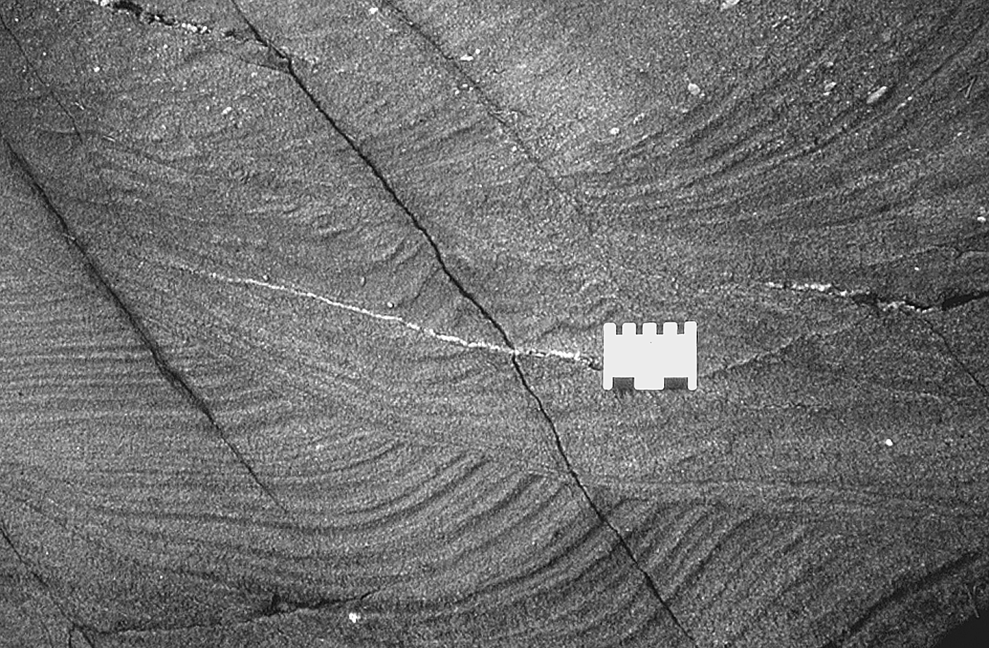
Figure 2.5. Concave-upward cross-bedding in Proterozoic-aged metamorphosed sandstone near Flin Flon, MB.
These rocks are complexly folded on a large scale, and the only way to solve the structure is to observe numerous way-up indicators, including cross-beds. The scale in the image is 5 cm across.
Cross-stratification occurs when a current transporting clastic grains (e.g., sand) encounters an irregularity on the surface it is flowing over. The current could be from waves in shallow water, from wind, or from river flow. The current erodes material from the upstream side (the stoss side) of the irregularity, and drops it on the downstream, or lee side. Over time, a dune-shaped structure such as the one shown in Figure 2.6b will form. This structure could be many metres high, such as dunes in the desert, or it could be a few centimetres tall, such as a ripple on a stream bed. With continued erosion on the stoss side, the peak of the dune will migrate downstream, and will leave concave-upward cross-beds behind. You can use the dip direction of the cross-beds to determine the downstream direction and the concave-upward shape to tell way-up.
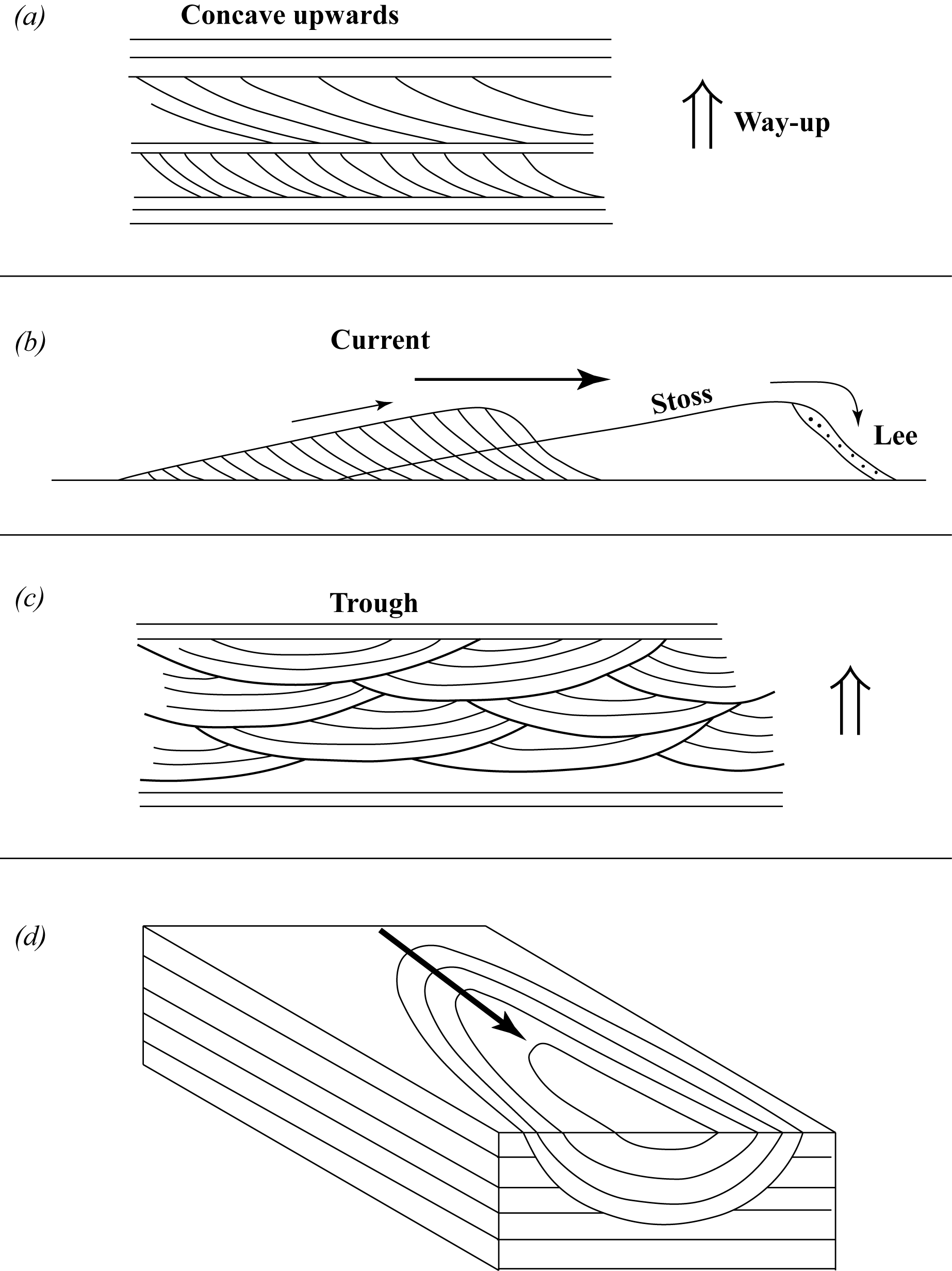
Figure 2.6. Development of cross-stratification
Trough cross-beds are another kind of cross-bed with a concave-upward shape that can be used to tell way-up. Trough cross-beds form under a variety of circumstances, but you would see the kind shown in Figure 2.6c if you viewed concave-upward cross-beds perpendicular to the flow direction, or if you looked at a section perpendicular to a filled stream channel. Channel-fill cross-strata form by deposition of layers on the down-current side. The pattern shown in Figure 2.6d is the result of a repeated sequence of channel erosion and fill, with early channel-fill material being only partly eroded away by later erosion.
The locations listed below have excellent outcrops of cross-beds. You can find more images of cross-stratification online by searching for images of these locations and including “cross-beds” in your search string:
- Pease Bay, Scotland
- Zion National Park, Utah
- Canyonlands National Park, Utah
- Vermillion Cliffs National Monument, Arizona
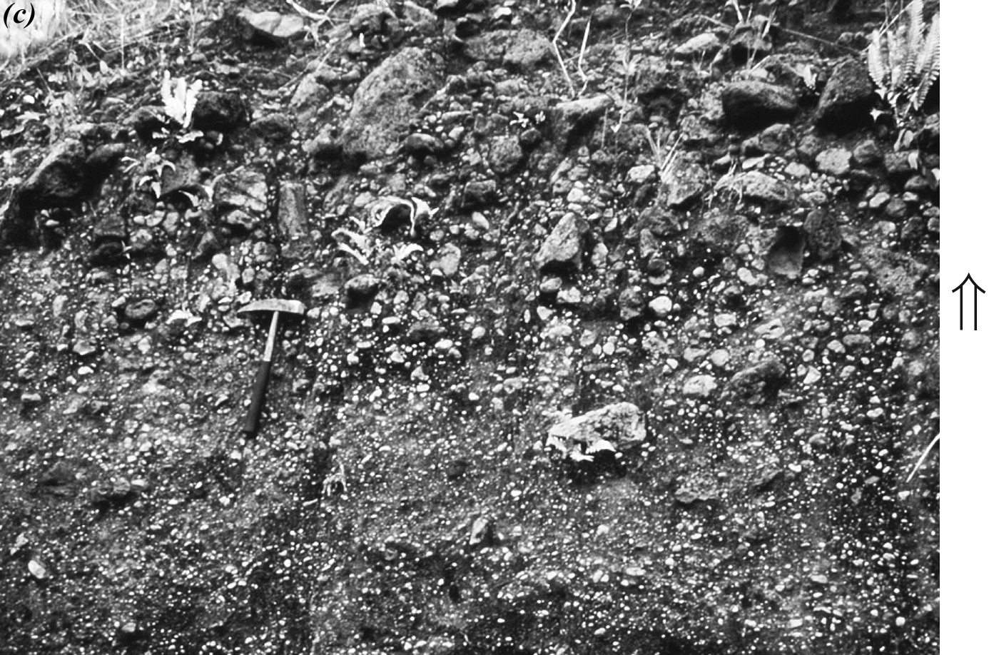
2.2. Graded Bedding
In a graded bed, also called a fining-upward sequence, grains decrease in size from bottom to top. Davis and Reynolds present a diagram of graded bedding in Figure C.5 (p. 658). Graded bedding is present in Figure C.10 (p. 659). Use Figure 2.7 below to help you pick out the fining-upward sequences. Note that the beds are not perfectly horizontal, because they have been deformed by small faults.
The range in grain size can be great, from gravel in the lower part of the bed, to silt at the top, but such extreme variation is rare. It is more common for the range in grain size to be much smaller, such as from coarse to fine sand, or from fine sand to silt.
Graded bedding develops when currents decrease in velocity and their particle-carrying power decreases. This occurs during the waning stages of a river flood or during the waning stages of a submarine landslide. Submarine landslides, called turbidity currents, are very important sedimentary processes. The deposits from turbidity currents, called turbidites, form a considerable proportion of the sedimentary rock record and commonly contain a number of sedimentary structures, including cross-stratification and graded bedding.
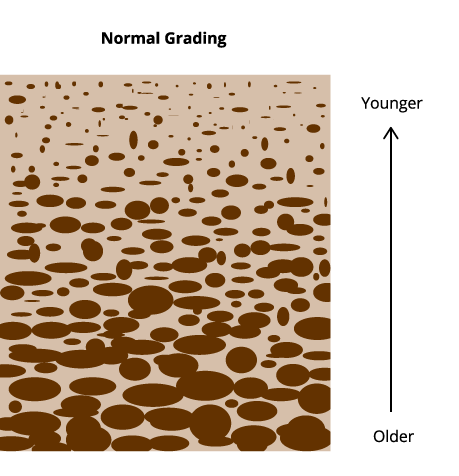
Figure 2.7. Graded Bedding.
Graded bedding refers to a change in grain size from larger grains to smaller ones, moving from the bottom of the bed to the top. “Schematic diagram showing … graded bedding in sedimentary rocks” by Reinhard Kirchner is licensed under CC BY-SA 3.0
2.3. Load Casts
Load casts form when irregular portions of one bed sink into the underlying bed (see Figs. 2.8 & 2.9). For this to occur, both beds must be weak (unlithified) and water-saturated. In this state, if the overlying bed has a higher density, it can sink into the lower bed. Sometimes the effect is slight, but it can also cause near complete disruption of beds. This process occurs in clastic sedimentary rocks where, in almost every case, coarser-grained sediments sink into finer-grained sediments. Several aspects of the resulting structures can be used to determine way-up:
- The sinking part (the ball) has a rounded bottom (Fig. 2.8b and c).
- The ball may become almost separated from its source bed, producing a neck (Fig. 2.8c).
- If the ball is completely separated, it can be matched to its source bed (Fig. 2.8d).
- Where two or more balls form near each other, the underlying bed will form sharp-peaked flames that point upward or into the overlying bed (Fig. 2.8e to g).
Figure 2.8g and h show that other patterns can form if either the upper or lower bed is made up of thin layers, or laminae. When the laminated bed is deformed, convolute bedding can develop, which may mimic tectonic folds.
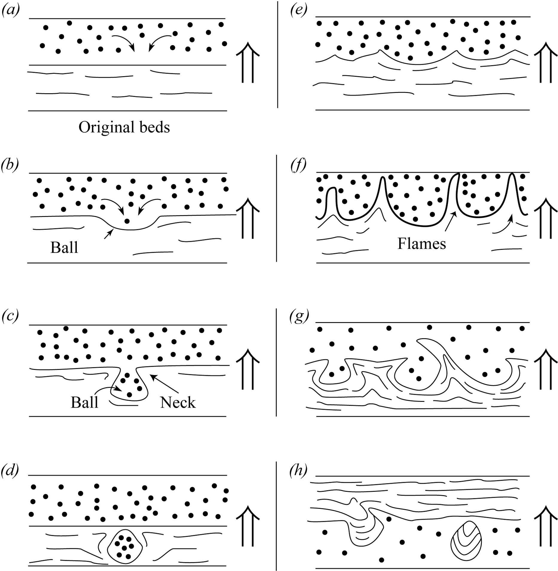
Figure 2.8. Development of load cast structures
Reading Assignment
- Read Davis, Reynolds, & Kluth: “D. Identifying Primary Structures” up to the third paragraph on page 708 (pp. 706–708)
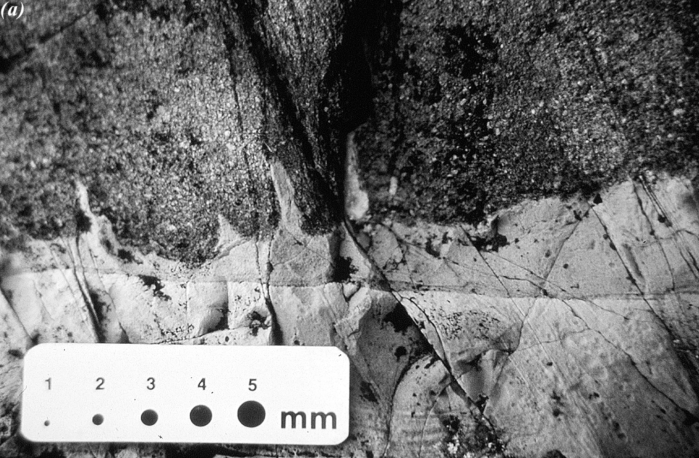
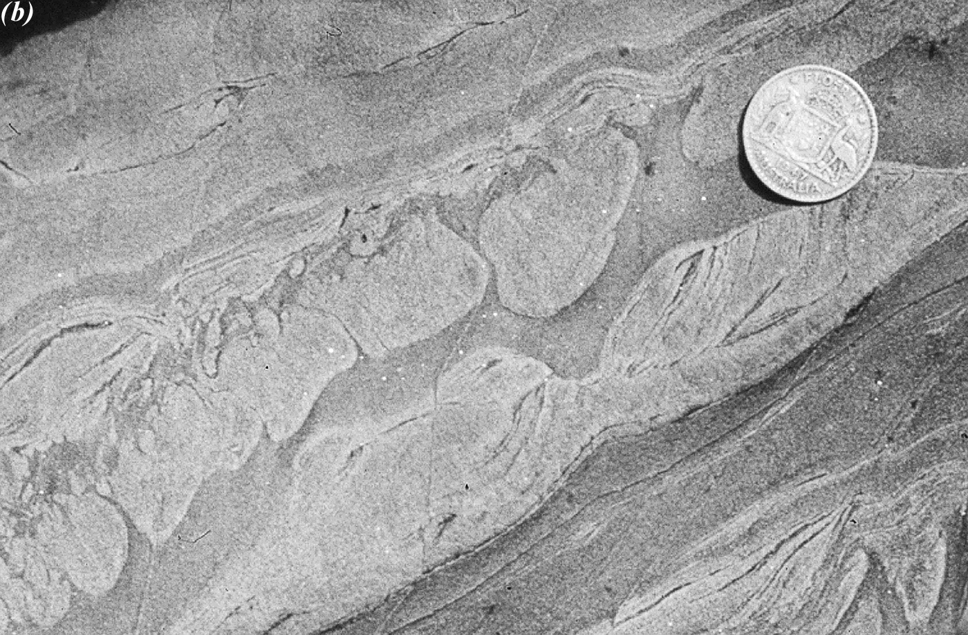
Figure 2.9. Examples of load cast structures.
Ball-like load casts and cross-bedding in small dunes or ripples, in Cambrian metamorphosed sandstone near Adelaide. South Australia. These rocks have Undergone a moderate amount of ductile deformation, causing the distortion just Observable in the photograph. The coin is about the size of a “Loonie.”
Study Questions
- Why is it important to know way-up before applying the principles of stratigraphy to interpret geological history?
- True or false: Cross-beds are a good way-up indicator regardless of the slope of the stoss side. Explain.
Lesson 3: Way-up Indicators in Lava Flows
There are four common way-up indicators in lava flows: vesicles, pillows, columnar structure, and ropy structure.
3.1. Vesicles
Vesicles form when small gas bubbles (microscopic to 10 cm across) get trapped in lava as it freezes (see Figs. 2.10 & 2.11). All lava contains gas, which is derived both from the rock that melted to produce the lava and from deep groundwater. Most of this gas is water vapour, but it also includes carbon dioxide, sulfur dioxide, and hydrogen sulfide (CO2, SO2, and H2S, respectively). At depth, these gases are held in solution within the magma by lithostatic pressure. However, as the magma rises, lithostatic pressure decreases, and the gases bubble out. The lava de-gasses in the same way that soda pop does when you decrease the pressure within the pop bottle by removing the cap.
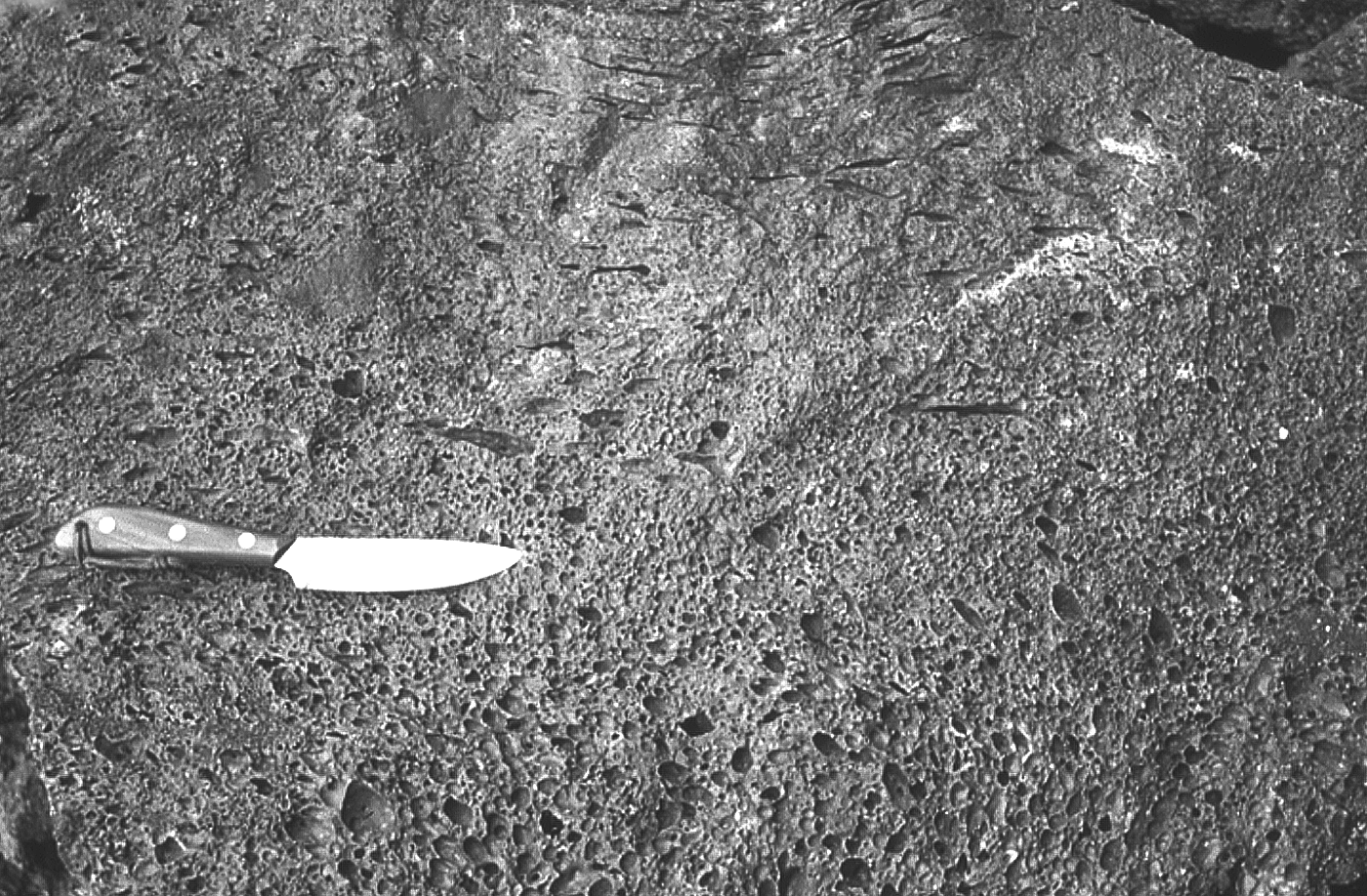
Figure 2.10. Normal and stretched vesicles in basalt
De-gassing can be violent, resulting in explosive eruptions, or it can be quiet, resulting in relatively gentle fountain-like spouting, or even more gentle oozing of the lava out of a vent in the volcano. (Note that the word gentle is used by geologic standards here—on volcanic scale).
Lavas erupted at mid-ocean ridges seldom contain vesicles, because the high hydrostatic pressure (the pressure of the overlying ocean) holds the gas in solution, and bubbles cannot form. Vesiculation is more common in relatively shallow waters (up to a few hundred metres deep), and in land-based (subaerial) eruptions. In the latter case, some lavas contain over 50% vesicles by volume. The muscle men in Figure 2.11 below are holding up a piece of basalt consisting of 75% vesicles, significantly reducing its potential mass. As such, the rock they are holding actually has a mass of 68 kg, or 150 lbs, rather than the ~270 kg, or 600 lbs it might weigh without the vesicles. The basalt in Figure 2.11 contains a high proportion of vesicles compared to most basaltic lava flows, which can have up to 50% porosity.

Figure 2.11. Two tough guys lifting a large block of vesicular lava at Craters of the Moon National Monument in Idaho
After vesicular lava has frozen, groundwater may precipitate minerals inside the vesicles. Such filled vesicles are called amygdules. Several features of vesicles (or amygdules) make them useful way-up indicators. Any of the following features may occur together:
- Vesicle grading (see Fig. 2.12a) occurs because the gas bubbles rise through the lava flow, but are trapped beneath the just-frozen skin. Therefore, there are more vesicles at the top of the lava flow than at the bottom. The gas bubbles also tend to expand and coalesce as they rise, so vesicles at the top also tend to be larger than vesicles at the bottom of the flow.
- Stretched vesicles (see Fig. 2.12b) form when the upper skin of the lava flow is too solid to permit vesicles to escape, yet still soft enough to flow. Any vesicles present at the top of the lava flow become stretched into cigar-shaped, or even thin, rod-like forms.
- Pipe vesicles form in lava that flows underwater or into water when steam is generated at the bottom of the lava flow. This only occurs in waters that are shallow enough that hydrostatic pressure will not prevent the water from boiling. The rising steam can leave cylindrical, vertical vesicles in the lower part of the flow.
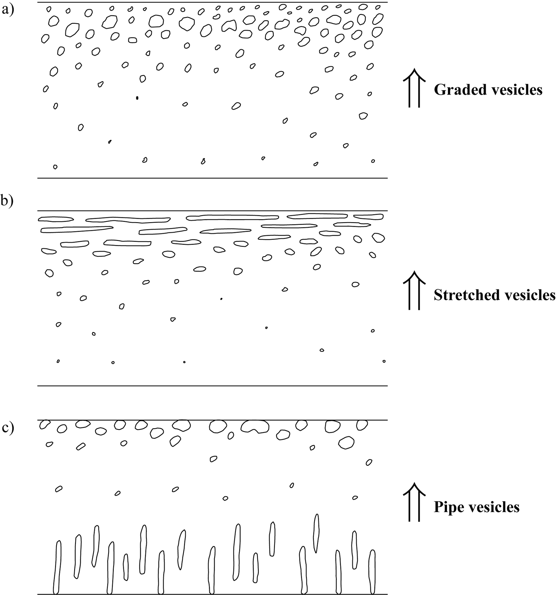
Figure 2.12. Way-up indicators in vesicular lava
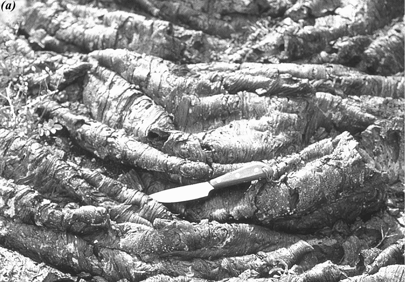
3.2. Pillow Lava
Lava flows often divide into tubes in the same way that a river divides into smaller streams when it reaches a delta. Large lava tubes may drain and become hollow, sometimes forming spectacular caves and caverns. If their roofs collapse, they form a highly irregular type of landform called pseudokarst topography. Tubes less than 1 m wide that flow into, or under, water develop bulbous or balloon-like features called pillows.
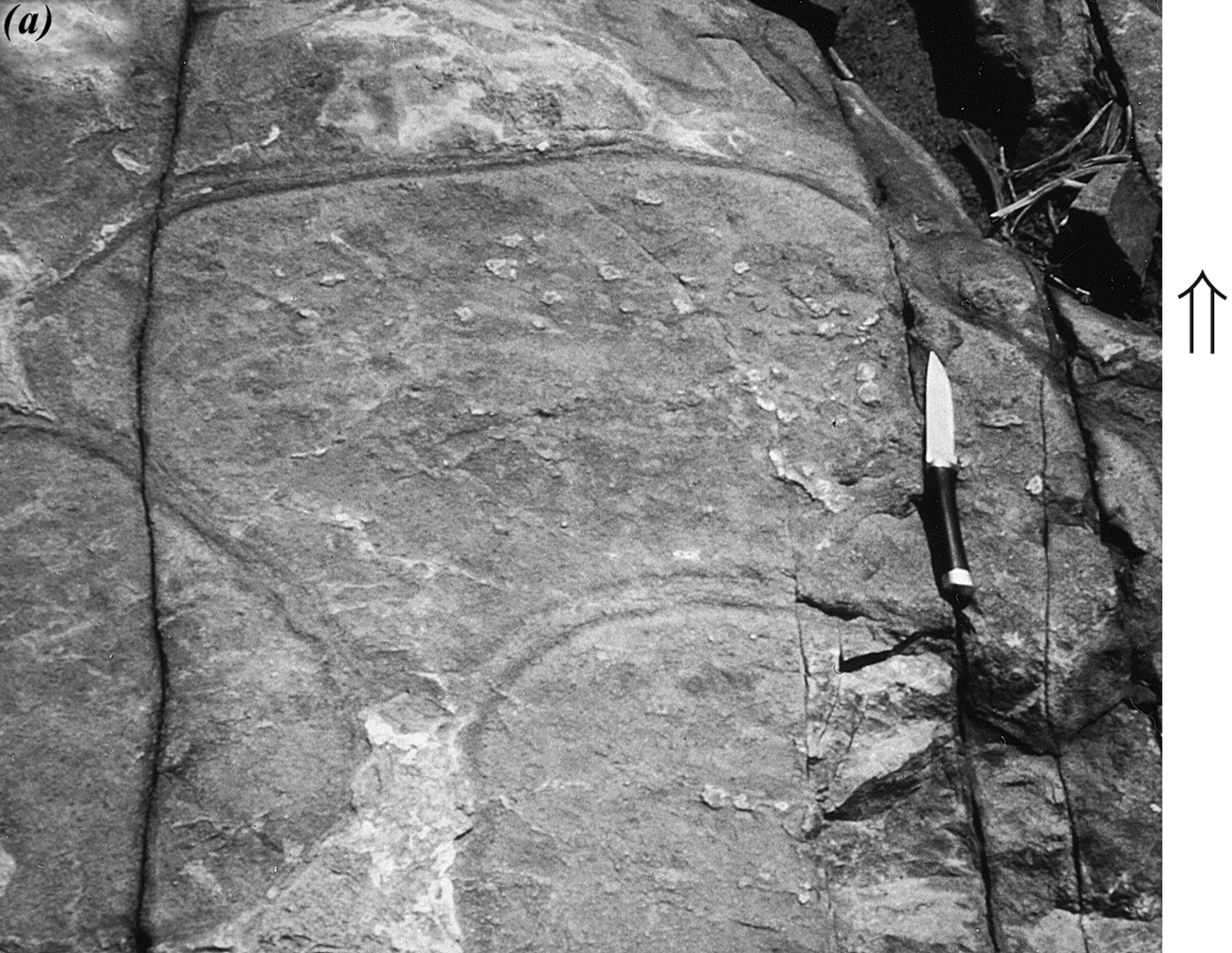
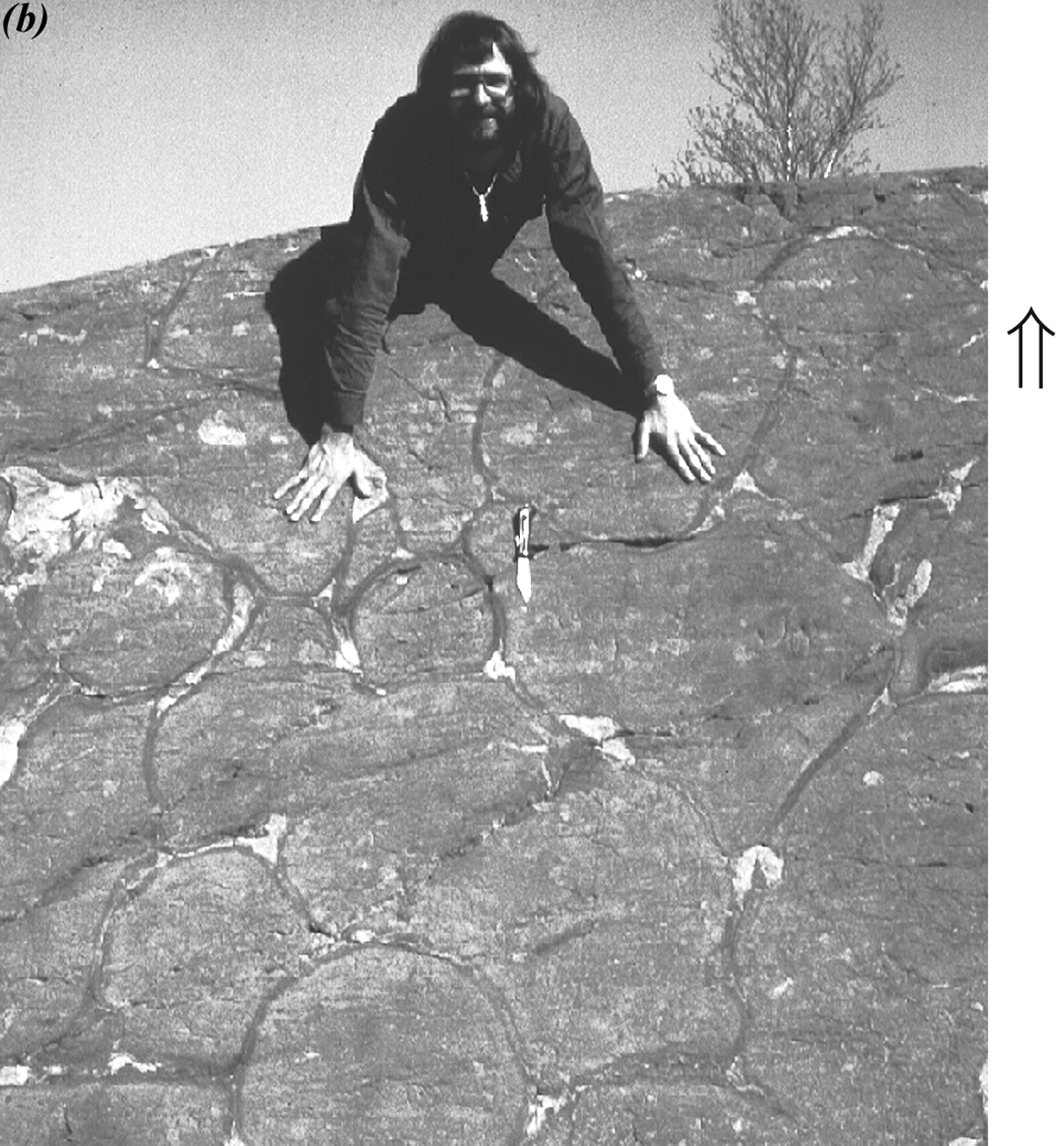
Figure 2.13. Pillows in Proterozoic basalt near Flin Flon, MB
Pillows form where the hot lava issuing from the end of the tube cools quickly upon contact with the water. In a matter of seconds, this “pillow” of lava blocks flow from the tube, and the tube diverts around or over the pillow, rapidly producing another pillow. In time, new pillows collect over old ones in a laterally expanding and thickening pile of pillow lava.
New pillows tend to drape over those previously formed, resulting in cross-sectional shapes with rounded tops and irregular bottoms, commonly with triangular tips pointing down (see Fig. D.9, Davis, Reynolds, & Kluth, p. 709). The classic pillow shape, resembling a bicycle seat, is shown in Fig. 2.13a.
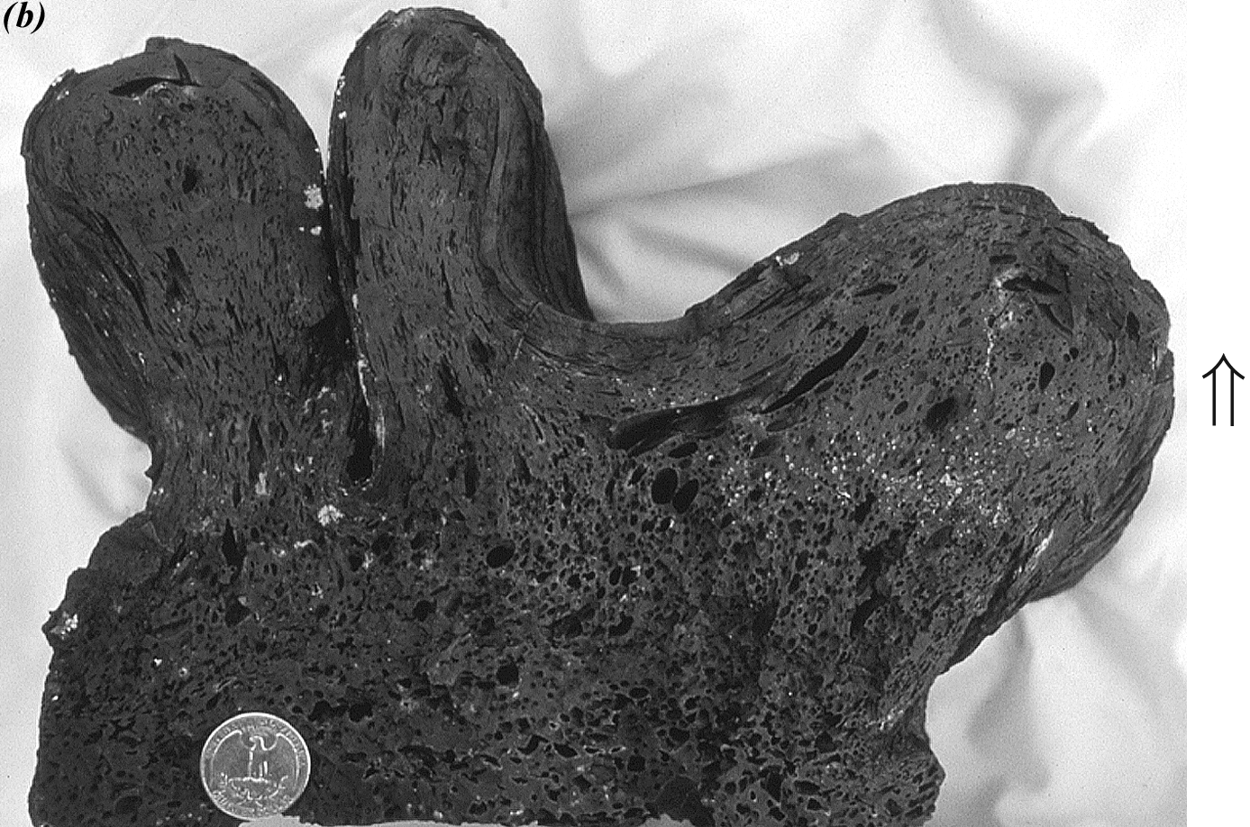
Pillows form best in basaltic lava. Many are vesiculated, some contain central drainage channels (see Fig. D.9, Davis, Reynolds, & Kluth, p. 709), and some have an array of cracks that formed when the pillows cooled and contracted. The outer edge of a pillow may have a rind of material, called a chilled margin, which develops when hot lava encounters seawater. The spaces between pillows become filled with fine volcanic ash (the proportion of ash to pillows varies). Compare the outcrop of pillows in Figure 2.13b, where there is very little volcanic ash between pillows, with that in Figure 2.14, where there is much more ash. The ash in Figure 2.14 has filled in some of the small, angular spaces between pillows so that new pillows tend to have more rounded bottoms than they do in Figure 2.13. It is still possible to tell way-up, however, because the tops of the pillows in Figure 2.14 tend to be more rounded than the bottoms.
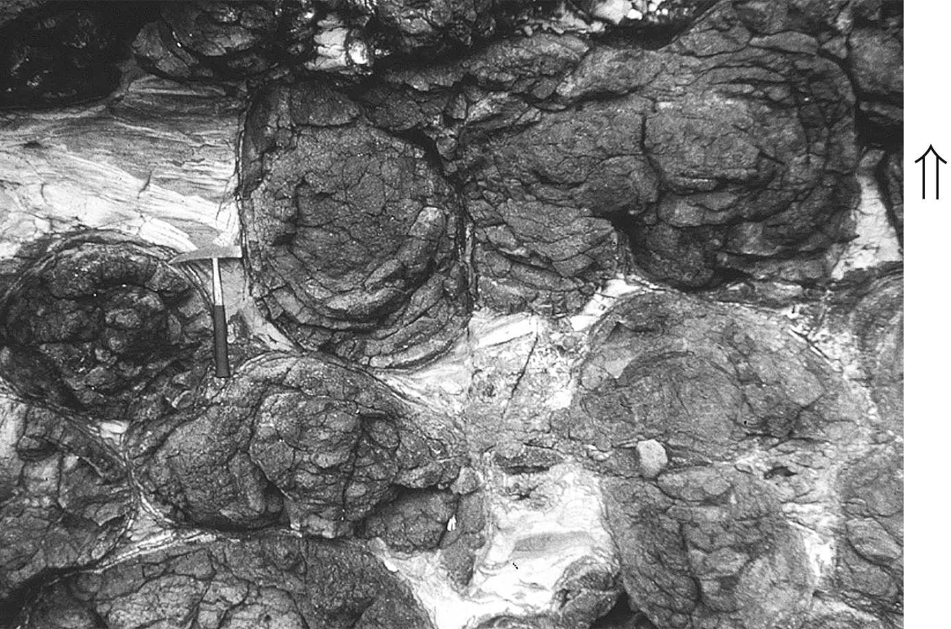
Figure 2.14. Pillows (dark) surrounded by volcanic ash in 10 Ma basalt on the Carribean island of Martinique
(note the hammer for scale)
This example illustrates an important point when trying to tell way-up from pillows, whether in outcrop, or from an image in this class: it is wise to look at more than one of the pillows to be sure that your interpretation of way-up is correct.
Pillow lava flows only through subaqueous (underwater) flow, especially along mid-ocean ridges and in the submarine parts of subduction-related volcanic arcs. Many excellent examples of pillow basalt are also present on the Hawaiian Islands. The common occurrence of thick, extensive sequences of pillow lavas on the continents today is an indication that much of the present-day continental area was born of the sea in the geological past. Today, pillow lava is the most common type of lava on Earth. In fact, some is probably forming somewhere on the sea floor at this very moment.
You can find more examples of pillow lava online. A search string such as “video of pillow basalt forming” will turn up some amazing video footage. Note that some of the footage demonstrates diving practices that are ill-advised (to say the least)—lava diving is dangerous!
3.3. Columnar Structure
Many non-pillowed lava flows, especially those formed on dry land, have a column-like appearance with polygonal cross-sections, like a bundle of hexagonal pencils (see Fig. 5.34, Davis, Reynolds, & Kluth, p. 212). These structures form when the lava cools, shrinks, and eventually cracks, in a manner similar to the formation of cracks in drying mud. Compare Figure 5.39 (Davis, Reynolds, & Kluth, p. 215) with Figure D.7 (p. 708).
Shrinkage cracks project down from the top of the lava flow and sometimes up from the base of the lava flow. The cracks break the lava into polygonal columns in a process called columnar jointing. The columns themselves vary from 1 m to about 30 m long, and from 20 cm to 2 m wide. They are most commonly hexagonal in cross-section, but can have three to eight sides. The appearance of the columns ultimately depends on the rate at which the lava cools.
Columnar structure can be used as a way-up indicator in some lavas, because columnar forms are usually restricted to the upper part of the flow, where heat is most rapidly transferred from the lava to the atmosphere above it
(Fig. 2.15a, below). When columns do form in the lower part of the flow, they are often much wider than the columns in the upper part, so it is still possible to determine way-up (Fig. 2.15b). In some rare flows, such as sills, the columnar structure occurs uniformly from bottom to top. In this case, the columnar structure does not provide information about way-up (Fig. 2.15c).
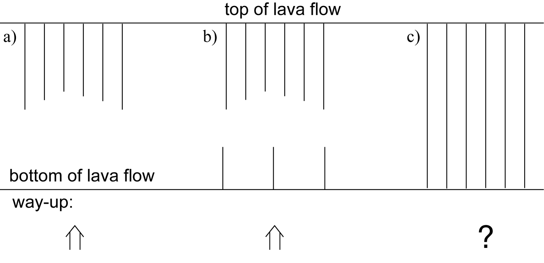
Figure 2.15. Columnar structure as a way-up indicator
3.4. Ropy Lava (Pahoehoe)
In low-viscosity (i.e., runny) lava, the surface of the lava flow may cool and form a skin, but the skin remains flexible. Lava continues to flow beneath the skin, causing the skin to wrinkle. The wrinkled lava is called pahoehoe (“pa-hoy-hoy”), or ropy lava (Fig. 2.16a, below). The wrinkles commonly form a sequence of nested arcs that are convex in the direction of flow. In Figure D.13 (Davis, Reynolds, & Kluth, p. 711), the direction of flow is from left to right.
The diameter of the “ropes” in different flows varies from approximately 1 to 10 cm. In larger ropes, complex refolding may occur. The formation of ropes at the top of the flow provides one way to determine way-up. This indicator, however, may not work in cases where the bottom part of the flow conforms to the shape of ropes on an underlying flow, thereby obscuring the way-up criteria. Most ropy lava is at least somewhat vesicular, however, and vesicles at the top of the lava flow commonly become stretched and conform to the shape of the ropes (Fig. 2.16b).
Ropy lava. Flow direction is toward the bottom of the photograph.
Cross-section through ropy lava showing stretched vesicles folded along with the ropes.
Figure 2.16. Flow direction and way-up indicators in ropy lava from Craters of the Moon National Monument
Study Questions
- What information (besides way-up) can pillow lavas provide about the environment in which the pillows formed?
- True or False: Vesicles can form in lava in any environment so long as the lava contains enough gas. Explain.
Lesson 4: Way-up Indicators in Pyroclastic Rocks
In addition to lava flows, volcanoes also throw out particles of various sizes. These particles are called pyroclastic material, or tephra. Pyroclastic material is generated in large volumes from explosive volcanic eruptions. An eruption will be explosive for one of two reasons:
- The magma within the volcano contains a large amount of gas, and degassing of the magma is violent.
- The magma comes into contact with water—groundwater, a lake, a river, the ocean, or even a glacier. The water flashes to steam and causes an explosion.
The pyroclastic material and the rocks that are formed from it are classified according to particle size:
- The finest material, ash, is the size of dust. Rocks consisting entirely of ash are called tuff.
- Bits from the size of grit to 2 cm in diameter are called lapilli. A lapilli tuff consists of ash with lapilli.
- Bombs are larger particles that are thrown out of the volcano as blobs of lava, and which freeze in the air or on the ground. Rocks made entirely of bombs are called agglomerate (these are rare).
- Blocks are bits larger than lapilli, which are thrown from the volcano after they have solidified. If blocks are present within a tuff, it is called a tuff breccia (pronounced “brech-a”). If blocks predominate, the rock is called a pyroclastic breccia.
After being blasted out of a vent, pyroclastic material comes to rest in one of three main ways:
- It falls out of the air as airfall or settles out in a body of water (waterfall). In either case, the material may be reworked by water currents or wind.
- On land, the collapse of an eruption column may cause a pyroclastic flow to form. The mix of hot pyroclastic debris and gas travels down the flanks of the volcano on a cushion of compressed air. The reduced friction permits pyroclastic flows to approach speeds of 700 km/h. Pyroclastic flows vary in volume, but they can be as large as 1000 km3, they can deposit material to a thickness of 500 m, and they can cover areas of over 10,000 km2. Pyroclastic flows are the leading cause of fatalities related to volcanic eruptions.
- A subaqueous volcanogenic turbidity current will form where a subaerial pyroclastic flow enters standing water, or where a pyroclastic eruption occurs under water. In either case, the particles form a slurry within the water, and the slurry flows downslope just like a landslide-generated turbidity current.
Many way-up indicators are produced by the deposition of pyroclastic materials, including almost every structure found in non-volcanogenic sedimentary rocks, and a few unique to pyroclastic deposits. Cross-bedding occurs in many airfall and volcanogenic turbidity current deposits, as does graded bedding (see Fig. 2.17a, below) and load casting. Load casts also commonly form where lava flows over water-saturated pyroclastic material.
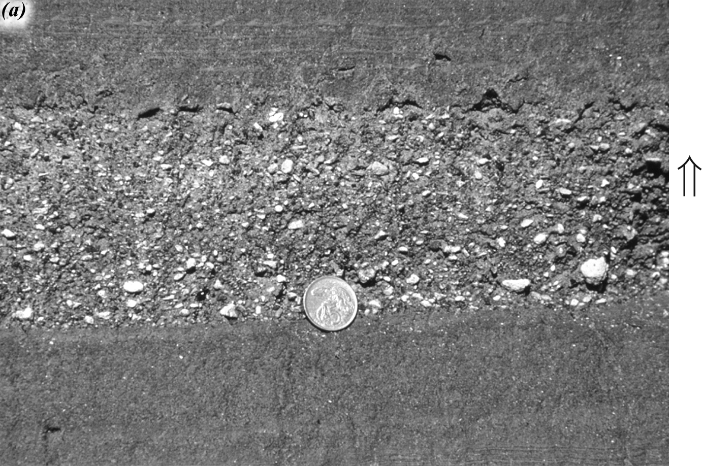
Normally graded pyroclastic flow composed of lapilli tuff. The coin is about the size of a Loonie.
Figure 2.17. Recent pyroclastic rocks from North Island, New Zealand
Subaerial pyroclastic flows are deposited hot, and as a result, some display columnar jointing. Unlike in lava flows, columnar jointing in pyroclastic flows is better developed near the base, where the flow was hottest. Some volcanic blocks and bombs land on water-saturated tephra, and variously indent or plough into it. The result is a way-up indicator called ballistic sag (see Fig. 2.17b, below).
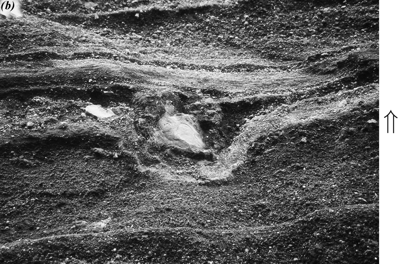
Ballistic sag with volcanic bomb in basaltic tuff. The area within the photograph is approximately 1 m across.
Figure 2.17. cont. Recent pyroclastic rocks from North Island, New Zealand
Reversed graded bedding occurs where the largest particles are in the upper part of the bed. It occasionally forms in river deposits, reflecting deposition under conditions of increasing stream velocity. It occurs in some airfall tephra deposits that formed as a volcano increased in explosive power during the eruption. If you suspect reversed graded bedding, you should test your interpretation against other way-up indicators in the deposit.
Grading in pyroclastic flows is complex. Some flows display no grading, while others have normal or reversed grading (see Fig. 2.17c). Grading depends in part on the characteristics of blocks thrown out by the volcano. Blocks that were fragments of the rock through which the magma rose or that were fragments of overlying material blasted by the explosion tend to be heavier than the tephra-gas mixture of the pyroclastic flow. As such, they will settle to the bottom of the pyroclastic flow as it travels. In contrast, blocks formed from the magma itself may be so intensely vesiculated that they are less dense than water. Pumice is an example of a highly vesiculated volcanic rock that can float on water. These light blocks can float to the top of the pyroclastic flow, resulting in reversed grading. If both dense and pumiceous blocks are present, the flow may at first appear to be ungraded. On closer inspection, however, the denser blocks may display normal grading, and the highly vesicular blocks may display reversed grading.
Reverse grading in a pumice-rich pyroclastic flow. Note the hammer for scale.
Figure 2.17. cont. Recent pyroclastic rocks from North Island, New Zealand
Study Questions
- What primary structures can be found in both pyroclastic and sedimentary rocks?
- What determines whether graded bedding will be normal or reversed?
Assignment 2
You should now complete the theory portion of Assignment 2, which you can find in the assignment drop box. You will submit this assignment to your tutor for grading after you have also completed the lab portion.
Answers to Study Questions
Lesson 1
- The easiest unconformity to find is the angular unconformity beneath bed E. The beds above the angular unconformity are horizontal, whereas the beds below the unconformity are folded. There is a disconformity between beds C and D. You can spot it because the contact between these beds is irregular compared to the other contacts, and because the unconformity truncates the igneous intrusion, F. There is a nonconformity between beds K and M. This contact is classified as a nonconformity because M is schist, a metamorphic rock, whereas K is sandstone, a sedimentary rock.
- Note: This geologic history is presented with an explanation to help you understand the reasoning involved. When you write a geologic history for an exam or assignment, you do not have to include the explanation unless it is specifically requested.
- Uplift and erosion exposed the schist. The schist (M) is the oldest rock based on the principle of superposition. In other words, it is on the bottom. The presence of the schist means that a parent rock was once formed, then buried and subjected to intense heat and pressure. Then the rocks were uplifted, and the schist was eventually exposed by erosion.
- Deposition of units K, L, I, J, H, and G (in that order), and perhaps additional units. We say deposition because the units in question are sedimentary rocks. We account for the possibility of other units (not shown in the cross-section) because they may have been eroded in the time represented by the unconformity beneath E.
- Folding occurred. The rocks were not deposited in folds (principle of original horizontality); therefore, they must have been deformed.
- Faulting occurred. Faulting is the best explanation for the truncation of folded strata (principle of horizontal continuity). The fault occurred after the folding because it cuts through folded strata, but is not folded itself (principle of cross-cutting relationships).
- Strata were uplifted and eroded. There is an angular unconformity beneath E that cuts both the fault and the folded sediments (principle of cross-cutting relationships). We say that strata were uplifted because the rocks must be exposed for erosion to take place.
- Strata were submerged, and units E, then D, and perhaps others were deposited. Strata had to be submerged for deposition to begin again. It is possible that sediments younger than D were once present, then eroded, because the surface beneath C is an unconformity.
- The gabbro dike (F) intruded. Igneous rocks that did not cool above ground are said to intrude. Igneous rocks that cooled above ground, such as those formed from lava flows or ash fall, are said to have been deposited.
- Uplift and erosion. We know that the surface beneath C is an unconformity, and that erosion occurred after the intrusion of the dike, because the dike is truncated by the unconformity (principle of cross-cutting relationships).
- Strata were submerged, and units C, B, and A were deposited in that order. Other beds may have been deposited as well.
- Nonconformities are depositional surfaces separating distinctly younger sedimentary or volcanic rocks above from distinctly older igneous or metamorphic rocks beneath.
An angular unconformity is an unconformity that separates layers above and below that are not parallel. Classical angular unconformities are horizontal depositional surfaces separating relatively young horizontal strata above from older steeply dipping strata below.
A disconformity is an unconformity separating strata that are parallel to each other.
For all three types of unconformity, the surface marking the unconformity is itself parallel to the bedding or layering of the rocks above the unconformity.
Lesson 2
- The principle of superposition states that beds will get younger from the bottom of a section to the top. However, this principle only applies if the beds are right-way-up. If beds are on their sides or are upside-down, then way-up indicators are required to determine which direction would have been way-up before the beds were disturbed.
- False. If the stoss side is straight rather than slightly curved, then it is not possible to tell way-up.
Lesson 3
- Pillows always form under water, so their presence indicates that the environment was submerged under water.
- False. For vesicles to form, the pressure must be low enough so that the gas can escape the melt and coalesce into bubbles. When lava erupts in deep water, such as along mid-ocean ridges, the pressure of the overlying water (hydrostatic pressure) is too great to permit bubbles (and by extension, vesicles) to form.
Lesson 4
- Graded beds, cross beds, and load casts can be found in both pyroclastic and sedimentary rocks. This is because although the material making up the pyroclastic rocks comes directly from a volcano, the material is deposited in the same way that sediments are deposited from any other source. This is why pyroclastic rocks are sometimes referred to as volcanogenic (i.e., volcano-derived) sediments.
- Whether graded bedding is normal or reversed in either pyroclastic or sedimentary rocks relates to the energy associated with the deposition of these materials. For example, a river that travels rapidly and turbulently during a flood will carry large particles (e.g., boulders), but as the flood wanes, it will carry smaller and smaller particles (e.g., sand, silt). This pattern would result in a normally graded bed. Similarly, if a volcanic eruption begins very violently, throwing out large blocks and bombs and ends more quietly by venting ash, it will normally produce graded bedding. In contrast, volcanogenic sediments may preserve a record of an increasingly violent eruption, beginning with ash, and ending with blocks and bombs. In this case, reverse-graded bedding would be the result. Reverse-graded bedding may also be produced when large, low-density particles (e.g., large blocks of pumice) are transported along with smaller, higher-density particles. The higher-density particles will tend to fall beneath the lower-density particles (the way unpopped popcorn kernels fall from between the popped ones to the bottom of the bowl), sorting themselves into reverse-graded bedding.